
Images


January 11, 2020 - Smoke and Contrails over Louisiana
 Tweet
Tweet
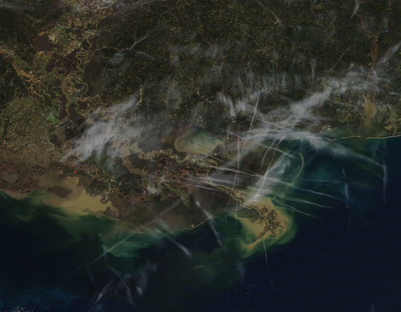
On January 8, 2020, the Moderate Resolution Imaging Spectroradiometer (MODIS) on board NASA’s Terra satellite acquired a true-color image of smoke and contrails in the skies over Louisiana.
Large areas of textured, brush-stroke-like gray mark smoke in the atmosphere, much of which rises from red hot spots. Best seen at high resolution in this image, each red hot spot marks an area where the thermal bands on the instrument detected areas of high temperature. When combined with typical smoke, such hot spots indicate actively burning fire. While no active fires were reported in Louisiana on Inciweb Incident Information System for January 8, winter is prime time for prescribed burns in Louisiana pine land. These burns are often used to reduce fuel, to remove young, unwanted hardwood, and control brownspot in pine stands.
In addition to smoke, a number of linear streaks criss-cross the region. These are contrails and were created by the passage of aircraft. Condensation trails, or contrails, are a type of cirrus cloud that forms in nearly the same way as naturally occurring cirrus. The difference lies in the source of ingredients. Aircraft exhaust contains an abundance of water vapor and small particles. At high altitudes, where it’s cold enough—at least -39°C (-38°F)—the water vapor can easily freeze onto the particles and form the long, narrow clouds. When the air temperature and humidity allow the ice crystals to stay solid, cirrus clouds can stick around for hours and move with the winds.
Image Facts
Satellite:
Terra
Date Acquired: 1/8/2020
Resolutions:
1km (193.4 KB), 500m (507 KB), 250m (327 KB)
Bands Used: 1,4,3
Image Credit:
MODIS Land Rapid Response Team, NASA GSFC
