
Images


March 19, 2020 - Fires in Victoria
 Tweet
Tweet
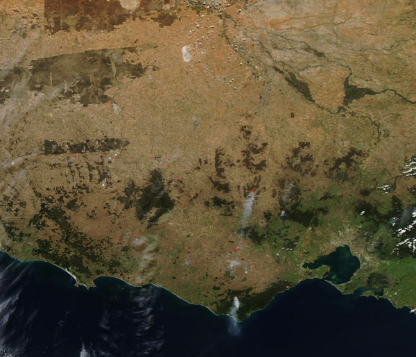
For much of the 2019-2020 austral summer, Victoria, Australia was ablaze with large numbers of wildfires. Thanks to soaring temperatures, dry vegetation, low humidity and gusty winds, the difficult bushfire season swept across the entire country, with New South Wales, Victoria, and Queensland hardest hit. According to the Center for Disaster Philanthropy (CDP), as of Feb. 15, 2020, more than 46 million acres (72,000 square miles) of land were burned in thousands of fires since June 2019.
Drenching rains fell in January in Victoria, with more in February. The wetter weather and the hard work of thousands of firefighters brought almost all of the fires under containment by late February. But Victoria’s bushfire season, while quiet, may not be completely over.
On March 16, 2020, the Moderate Resolution Imaging Spectroradiometer (MODIS) on board NASA’s Aqua satellite acquired a true-color image of fires burning in Victoria.
Each red “hot spot” marks an area where the thermal bands on the instrument detected high temperatures. When combined with typical smoke, as in this image, such hot spots are diagnostic for actively burning fire.
Most of the fires appear to be burning in forested areas, with only a few in lightly vegetated, potentially agricultural areas. According to the Australian government’s VicEmergency website, the fires appear to be a mix of both planned burns, which are used to manage land, and bushfires. While most of the bushfires are contained, some are not yet under control.
Image Facts
Satellite:
Aqua
Date Acquired: 3/16/2020
Resolutions:
1km (127.7 KB), 500m (375.3 KB), 250m (845.9 KB)
Bands Used: 1,4,3
Image Credit:
MODIS Land Rapid Response Team, NASA GSFC
For much of the 2019-2020 austral summer, Victoria, Australia was ablaze with large numbers of wildfires. Thanks to soaring temperatures, dry vegetation, low humidity and gusty winds, the difficult bushfire season swept across the entire country, with New South Wales, Victoria, and Queensland hardest hit. According to the Center for Disaster Philanthropy (CDP), as of Feb. 15, 2020, more than 46 million acres (72,000 square miles) of land were burned in thousands of fires since June 2019.
Drenching rains fell in January in Victoria, with more in February. The wetter weather and the hard work of thousands of firefighters brought almost all of the fires under containment by late February. But Victoria’s bushfire season, while quiet, may not be completely over.
On March 16, 2020, the Moderate Resolution Imaging Spectroradiometer (MODIS) on board NASA’s Aqua satellite acquired a true-color image of fires burning in Victoria. Each red “hot spot” marks an area where the thermal bands on the instrument detected high temperatures. When combined with typical smoke, as in this image, such hot spots are diagnostic for actively burning fire.
Most of the fires appear to be burning in forested areas, with only a few in lightly vegetated, potentially agricultural areas. According to the Australian government’s VicEmergency website, the fires appear to be a mix of both planned burns, which are used to manage land, and bushfires. While most of the bushfires are contained, some are not yet under control.
Image Facts
Satellite:
Aqua
Date Acquired: 3/16/2020
Resolutions:
1km (127.7 KB), 500m (375.3 KB), 250m (845.9 KB)
Bands Used: 1,4,3
Image Credit:
MODIS Land Rapid Response Team, NASA GSFC
