
Images


March 24, 2020 - Flooding in Ohio
 Tweet
Tweet
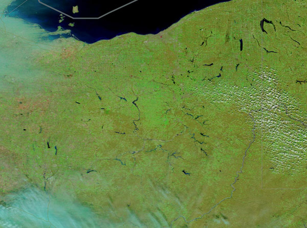
After a short period of severe storms, much of central Ohio experienced flash flooding on March 20, 2020. According to the National Weather Service, Columbus, Ohio, set record rainfall for the March 20 date. More than 2.88 inches fell on that date, breaking the former record of 1.60 inches set in 1984. According to the Columbus Dispatch, up to 4 inches of rain that fell in parts of Licking County over a 48-hour time span caused dozens of evacuations and a portion of Route 79 to collapse. The Dispatch also reported that two temporary shelters were set up for the evacuees, and that “Olivia Biggs, spokeswoman for Licking County Health Department, said officials were taking precautions to maintain social distancing within the shelters and were examining everyone who came in to prevent spread of the coronavirus.”
The Moderate Resolution Imaging Spectroradiometer (MODIS) on board NASA’s Terra satellite acquired a false-color image of central and northern Ohio on March 22.
This type of false-color image uses infrared and visible light to highlight water and vegetation. Vegetation appears bright green, cloud appears white to electric blue, while water appears light blue to deep inky blue, depending on depth. In this image, numerous lakes and rivers can be seen across the region. Several of the waterways in the lower portion of the image, to the left of center, appear lighter blue. These are flooded rivers and lakes located in Licking County, just east of the city of Columbus. Columbus appears to be covered with cloud.
To better see the flooded area, a roll-over comparison between Terra MODIS images acquired on March 20 and on February 22 can be seen
HERE, thanks to the NASA Worldview app.
The NASA Worldview app provides a satellite's perspective of the planet as it looks today and as it has in the past through daily satellite images. Worldview is part of NASA’s Earth Observing System Data and Information System. EOSDIS makes the agency's large repository of data accessible and freely available to the public.
Image Facts
Satellite:
Terra
Date Acquired: 3/22/2020
Resolutions:
1km (65.6 KB), 500m (192.4 KB), 250m (292.9 KB)
Bands Used: 7,2,1
Image Credit:
MODIS Land Rapid Response Team, NASA GSFC
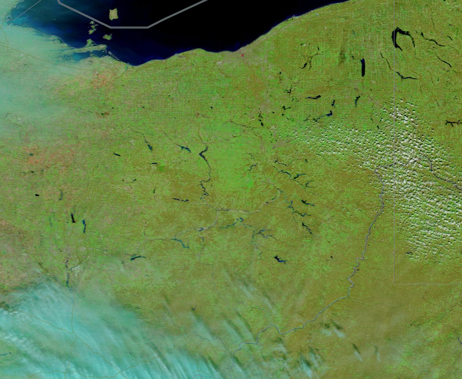
After a short period of severe storms, much of central Ohio experienced flash flooding on March 20, 2020. According to the National Weather Service, Columbus, Ohio, set record rainfall for the March 20 date. More than 2.88 inches fell on that date, breaking the former record of 1.60 inches set in 1984. According to the Columbus Dispatch, up to 4 inches of rain that fell in parts of Licking County over a 48-hour time span caused dozens of evacuations and a portion of Route 79 to collapse. The Dispatch also reported that two temporary shelters were set up for the evacuees, and that “Olivia Biggs, spokeswoman for Licking County Health Department, said officials were taking precautions to maintain social distancing within the shelters and were examining everyone who came in to prevent spread of the coronavirus.”
The Moderate Resolution Imaging Spectroradiometer (MODIS) on board NASA’s Terra satellite acquired a false-color image of central and northern Ohio on March 22.
This type of false-color image uses infrared and visible light to highlight water and vegetation. Vegetation appears bright green, cloud appears white to electric blue, while water appears light blue to deep inky blue, depending on depth. In this image, numerous lakes and rivers can be seen across the region. Several of the waterways in the lower portion of the image, to the left of center, appear lighter blue. These are flooded rivers and lakes located in Licking County, just east of the city of Columbus. Columbus appears to be covered with cloud.
To better see the flooded area, a roll-over comparison between Terra MODIS images acquired on March 20 and on February 22 can be seen HERE, thanks to the NASA Worldview app.
The NASA Worldview app provides a satellite's perspective of the planet as it looks today and as it has in the past through daily satellite images. Worldview is part of NASA’s Earth Observing System Data and Information System. EOSDIS makes the agency's large repository of data accessible and freely available to the public.
Image Facts
Satellite:
Terra
Date Acquired: 3/22/2020
Resolutions:
1km (65.6 KB), 500m (192.4 KB), 250m (292.9 KB)
Bands Used: 7,2,1
Image Credit:
MODIS Land Rapid Response Team, NASA GSFC
