Images
May 16, 2020 - Typhoon Vongfong
Tweet
The first tropical storm in the Western Pacific Ocean in 2020 made landfall in the Philippines with fierce winds and heavy rainfall on May 14. Prior to landfall, civil authorities worked to evacuate tens to hundreds of thousands of people from coastal and mountainous areas prone to flooding and landslides, all with an eye to attempting to maintain safe distancing required to minimize the spread of COVID-19. Shelters have aimed to keep populations low, while churches and shopping centers offered additional shelter space.
Typhoon Vongfong (named Ambo in the Philippines) made its first landfall in the province of Eastern Samar around noon local time on May 14. Shortly before landfall, the storm had sustained winds of 100 knots (115 miles/185 kilometers per hour), according to the Joint Typhoon Warning Center. The Philippine Atmospheric, Geophysical, and Astronomical Services Administration rated the storm as category 3 on their wind scale. After striking Eastern Samar, the typhoon made additional landfalls on Dalupiri Island, Capul Island, Ticao Island, Burias Island, and San Andreas, then turned towards Luzon still carrying maximum sustained winds of about 125 km/h (77.7 mph).
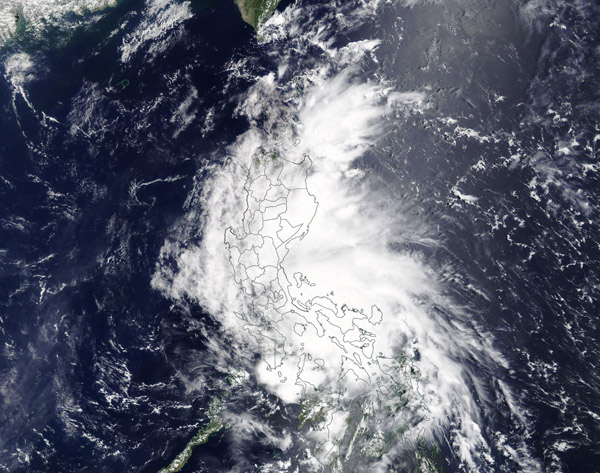
On May 15 the Moderate Resolution Imaging Spectroradiometer (MODIS) on board NASA’s Terra satellite acquired a true-color image of Vongfong as it stretched across the Philippines. Now at tropical cyclone strength, the storm had lost an open eye and was elongated in shape.
Vongfong was predicted to move north-northwest across most of the large Philippine Islands through May 16, including Luzon (the most populated). Some weather models predicted as much as 25 to 50 centimeters (10 to 20 inches) of rainfall in places.
Image Facts
Satellite:
Terra
Date Acquired: 5/15/2020
Resolutions:
1km (587.9 KB), 500m (2 MB), 250m (5.4 MB)
Bands Used: 1,4,3
Image Credit:
MODIS Land Rapid Response Team, NASA GSFC


