Images
June 24, 2020 - Saharan Dust over the Caribbean
Tweet
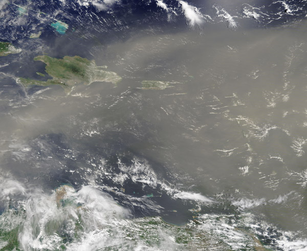
Riding high on a layer of dry air, dust from the Sahara Desert reached the Caribbean on June 22, 2020, covering the region with a thick tan plume. The Moderate Resolution Imaging Spectroradiometer (MODIS) on board NASA’s Terra satellite acquired a true-color image of the plume as it reached the island of Hispaniola on its way to Puerto Rico and, before long, to the United States and South America.
Some dust began to blow off of the coast of north-western African on June 5—a common occurrence in the often-windswept Sahara Desert. The initial motion of the dust stayed relatively close to Africa, reaching but not far exceeding the Cape Verde Islands, roughly 400 miles west of Dakar, Senegal.
By June 15, large sheets of dust flowed off of Morocco, Mauritania, and Senegal and began to make substantial progress across the Atlantic Ocean.
Normally, hundreds of millions of tons of dust are picked up from the deserts of Africa and blown across the Atlantic Ocean each year. That dust helps build beaches in the Caribbean and fertilizes soils in the Amazon. It affects air quality in North and South America. It likely plays a role in the suppression of hurricanes and the decline of coral reefs as well. Extremely large dust events, like this one, are unusual.
The Saharan dust is forecast to move into the Gulf of Mexico, over Texas and into the lower Mississippi River Valley and Florida by June 26, before turning northeast to potentially reach the Mid Atlantic before July 1.
Image Facts
Satellite:
Terra
Date Acquired: 6/22/2020
Resolutions:
1km (619 KB), 500m (1.9 MB), 250m (3.7 MB)
Bands Used: 1,4,3
Image Credit:
MODIS Land Rapid Response Team, NASA GSFC
Tweet
Riding high on a layer of dry air, dust from the Sahara Desert reached the Caribbean on June 22, 2020, covering the region with a thick tan plume. The Moderate Resolution Imaging Spectroradiometer (MODIS) on board NASA’s Terra satellite acquired a true-color image of the plume as it reached the island of Hispaniola on its way to Puerto Rico and, before long, to the United States and South America.
Some dust began to blow off of the coast of north-western African on June 5—a common occurrence in the often-windswept Sahara Desert. The initial motion of the dust stayed relatively close to Africa, reaching but not far exceeding the Cape Verde Islands, roughly 400 miles west of Dakar, Senegal.
By June 15, large sheets of dust flowed off of Morocco, Mauritania, and Senegal and began to make substantial progress across the Atlantic Ocean. Normally, hundreds of millions of tons of dust are picked up from the deserts of Africa and blown across the Atlantic Ocean each year. That dust helps build beaches in the Caribbean and fertilizes soils in the Amazon. It affects air quality in North and South America. It likely plays a role in the suppression of hurricanes and the decline of coral reefs as well. Extremely large dust events, like this one, are unusual.
The Saharan dust is forecast to move into the Gulf of Mexico, over Texas and into the lower Mississippi River Valley and Florida by June 26, before turning northeast to potentially reach the Mid Atlantic before July 1.
Image Facts
Satellite:
Terra
Date Acquired: 6/22/2020
Resolutions:
1km (619 KB), 500m (1.9 MB), 250m (3.7 MB)
Bands Used: 1,4,3
Image Credit:
MODIS Land Rapid Response Team, NASA GSFC


