
Images


June 27, 2020 - Northwestern United States
 Tweet
Tweet
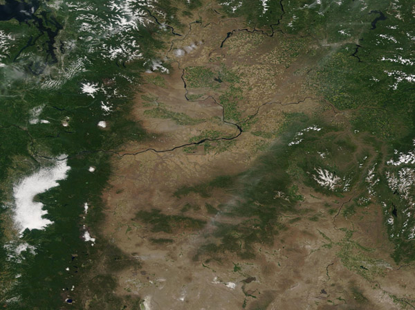
The Moderate Resolution Imaging Spectroradiometer (MODIS) on board NASA’s Terra satellite acquired a broad view of the Cascade Mountains and Columbia Basin in the Northwestern United States on June 25, 2020.
The Columbia River, the largest river in the Pacific Northwest, rises from Columbia Lake high near the crest of the Rocky Mountains in British Columbia, Canada. Flowing northwesterly for about 190 miles (305 km), the river then turns south to cross the border between Canada and the United States, and then sweeps across the state of Washington in a sweeping curve before forming the boundary between Washington and Oregon. Heading towards the mountains, the Columbia River cuts through the Cascades at the Columbia River Gorge on its way to pour into the Pacific Ocean. It is the only river to cut through the Cascade Range.
The snow-capped tops of some of the higher peaks in the Cascades stand out against the green vegetation surrounding the peaks. Mount Rainer, in particular, stands out in sharp relief. A large bank of fog clings to the western slope of the Cascades.
Greener, forested landscapes, and fog are evidence of the wet climate experienced by people who live near the coast and on the seaward slopes of the mountains. By contrast, the tan colors of the dry Columbia Basin show the rain shadow effect of the Cascades in preventing rain-bearing air masses from reaching the basin. Light green that washes part of the Columbia Basin, particularly near the Columbia River, mark agricultural fields. Each field is irrigated as the dry climate would not otherwise allow crops, such as vineyards, to thrive without additional water.
Image Facts
Satellite:
Terra
Date Acquired: 6/25/2020
Resolutions:
1km (220.9 KB), 500m ( B), 250m (1.1 MB)
Bands Used: 1,4,3
Image Credit:
MODIS Land Rapid Response Team, NASA GSFC
