
Images


July 12, 2020 - Meadow Valley Fire Burn scars
 Tweet
Tweet
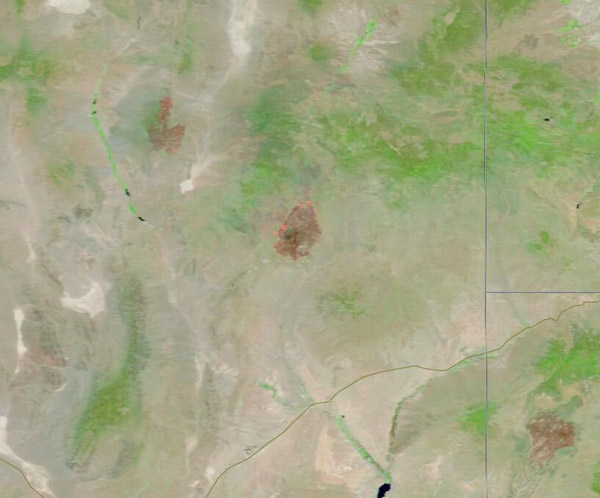
At about 6:30 p.m. on Tuesday, July 7, 2020, a small fire was first reported burning about 25 miles south of Caliente, Nevada. The flames quickly became an inferno, with over 56,000 acres burnt by the morning of July 10. Using smokejumpers, Type 1 hand crews, Type 2 Initial Attack hand crews, engines, water tenders, bulldozers, helicopters and air tankers the blaze was 50 percent contained on July 11.
According to Inciweb Incident Information System, the fire is burning in tall grass, short grass, and brush, without threat to private property. The site is desert tortoise and bighorn sheep habitat within and outside of the Meadow Valley Range Wilderness. The desert tortoise (Gopherus agassizi) is listed as "threatened" under the United States federal Endangered Species Act and is considered “vulnerable” by the International Union for Conservation of Nature (IUCN).
On July 8, the Moderate Resolution Imaging Spectroradiometer (MODIS) on board NASA’s Terra satellite acquired a stunning false-color image that highlights the burn scar of the actively raging fire. Although the Meadow Fire was not yet 24 hours old, the brown area in the center of the image marks a large area where the fire has removed vegetation. In this type of false-color imagery, vegetation is bright green, open soil is tan, and burn scar can appear anywhere from brick red to charred-black. The red spots at the edge of the scar mark areas where the thermal bands on the instrument detected high temperatures, which match actively burning fire.
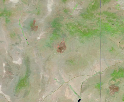
While the single image clearly shows a large burn scar, it cannot illustrate the rapid growth of the fire. Thanks to the NASA Worldview App, pairs of images can be easily compared, which makes it easy to see changes in the landcover over time. To see a rollover comparison between images captured by the MODIS on Terra on July 1 (before the fire) and July 8, the day after the fire ignited, click
here.
Image Facts
Satellite:
Terra
Date Acquired: 7/8/2020
Resolutions:
1km (24.5 KB), 500m (46 KB), 250m (47.3 KB)
Bands Used: 7,2,1
Image Credit:
MODIS Land Rapid Response Team, NASA GSFC
At about 6:30 p.m. on Tuesday, July 7, 2020, a small fire was first reported burning about 25 miles south of Caliente, Nevada. The flames quickly became an inferno, with over 56,000 acres burnt by the morning of July 10. Using smokejumpers, Type 1 hand crews, Type 2 Initial Attack hand crews, engines, water tenders, bulldozers, helicopters and air tankers the blaze was 50 percent contained on July 11.
According to Inciweb Incident Information System, the fire is burning in tall grass, short grass, and brush, without threat to private property. The site is desert tortoise and bighorn sheep habitat within and outside of the Meadow Valley Range Wilderness. The desert tortoise (Gopherus agassizi) is listed as "threatened" under the United States federal Endangered Species Act and is considered “vulnerable” by the International Union for Conservation of Nature (IUCN).
On July 8, the Moderate Resolution Imaging Spectroradiometer (MODIS) on board NASA’s Terra satellite acquired a stunning false-color image that highlights the burn scar of the actively raging fire. Although the Meadow Fire was not yet 24 hours old, the brown area in the center of the image marks a large area where the fire has removed vegetation. In this type of false-color imagery, vegetation is bright green, open soil is tan, and burn scar can appear anywhere from brick red to charred-black. The red spots at the edge of the scar mark areas where the thermal bands on the instrument detected high temperatures, which match actively burning fire.
While the single image clearly shows a large burn scar, it cannot illustrate the rapid growth of the fire. Thanks to the NASA Worldview App, pairs of images can be easily compared, which makes it easy to see changes in the landcover over time. To see a rollover comparison between images captured by the MODIS on Terra on July 1 (before the fire) and July 8, the day after the fire ignited, click here.
Image Facts
Satellite:
Terra
Date Acquired: 7/8/2020
Resolutions:
1km (24.5 KB), 500m (46 KB), 250m (47.3 KB)
Bands Used: 7,2,1
Image Credit:
MODIS Land Rapid Response Team, NASA GSFC
