Images
September 10, 2020 - Tropical Storm Rene
Tweet
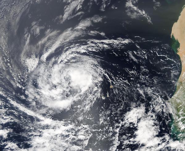
Tropical Storm Rene was drenching the Cape Verde Islands on September 8, 2020, when the Moderate Resolution Imaging Spectroradiometer (MODIS) on board NASA’s Aqua satellite acquired this true-color image of the storm. The Republic of Cape Verde consists of about ten islands and sits about 385 miles (620 km) off the western coast of Africa.
Tropical Depression 18 developed on Monday September 7 in the far eastern North Atlantic Ocean, about 250 miles (405 km) east-southeast of the Cabo Verde Islands. By 5 p.m. EDT (2100 UTC) that same afternoon, the depression strengthened into a tropical storm and was renamed Rene.
At 11 a.m. EDT (1500 UTC) on September 8, Tropical Storm Rene was bringing tropical-storm-force winds and heavy rain to the western Cabo Verde Islands. The center of Tropical Storm Rene was located near latitude 16.5 degrees north and longitude 26.5 degrees west. Rene was moving toward the west near 16 mph (26 kph).
As the storm moved over the rugged island terrain on September 8, it also met substantial easterly wind shear. By the morning of September 9 Rene had weakened to tropical-depression strength. By that afternoon, Rene had pulled away from the islands and began to strengthen, increasing wind speeds to 40 mph (65 mph) and it once again earned the name Tropical Storm Rene.
The National Hurricane Center (NHC) forecasts gradual strengthening over the next several days and Tropical Storm Rene is expected to become a hurricane later this week as it moves over open ocean.
Image Facts
Satellite:
Aqua
Date Acquired: 9/8/2020
Resolutions:
1km (617.6 KB), 500m (1.9 MB), 250m (5.5 MB)
Bands Used: 1,4,3
Image Credit:
MODIS Land Rapid Response Team, NASA GSFC
Tweet
Tropical Storm Rene was drenching the Cape Verde Islands on September 8, 2020, when the Moderate Resolution Imaging Spectroradiometer (MODIS) on board NASA’s Aqua satellite acquired this true-color image of the storm. The Republic of Cape Verde consists of about ten islands and sits about 385 miles (620 km) off the western coast of Africa.
Tropical Depression 18 developed on Monday September 7 in the far eastern North Atlantic Ocean, about 250 miles (405 km) east-southeast of the Cabo Verde Islands. By 5 p.m. EDT (2100 UTC) that same afternoon, the depression strengthened into a tropical storm and was renamed Rene. At 11 a.m. EDT (1500 UTC) on September 8, Tropical Storm Rene was bringing tropical-storm-force winds and heavy rain to the western Cabo Verde Islands. The center of Tropical Storm Rene was located near latitude 16.5 degrees north and longitude 26.5 degrees west. Rene was moving toward the west near 16 mph (26 kph).
As the storm moved over the rugged island terrain on September 8, it also met substantial easterly wind shear. By the morning of September 9 Rene had weakened to tropical-depression strength. By that afternoon, Rene had pulled away from the islands and began to strengthen, increasing wind speeds to 40 mph (65 mph) and it once again earned the name Tropical Storm Rene.
The National Hurricane Center (NHC) forecasts gradual strengthening over the next several days and Tropical Storm Rene is expected to become a hurricane later this week as it moves over open ocean.
Image Facts
Satellite:
Aqua
Date Acquired: 9/8/2020
Resolutions:
1km (617.6 KB), 500m (1.9 MB), 250m (5.5 MB)
Bands Used: 1,4,3
Image Credit:
MODIS Land Rapid Response Team, NASA GSFC


