
Images


December 25, 2020 - Snow in Western United States
 Tweet
Tweet
When Americans celebrate the Christmas holiday each December 25, they are likely to have their homes decorated with traditional “Christmas colors” – red and green. If you ask why these colors represent what is, for many, a high holy day, you are likely to garner answers that span a gamut from secular to religious. Kids may say green is for the Christmas tree and red stands for the bright nose of Santa’s lead reindeer, Rudolph. Christians may explain that the color of evergreen trees represents eternal life and hope, as the trees endure the harshest winters and remain alive and that red represents the blood of Christ, whose birth is celebrated on this day. Others speculate that the colors of the season come from the holly tree, whose bright red berries and stunning green foliage stand out beautifully against snow – and was used by ancient Romans to decorate their homes for Saturnalia, a celebration held on the shortest days of the year, from December 17-23. Then again, some historians claim that these colors became popular symbols of Christmas in America due to widespread advertising by the Coca-Cola company in the early 1930s. The ads highlighted the company’s green glass bottles of soda being held by a red-suited Santa and became, themselves, a symbol of an American Christmas.
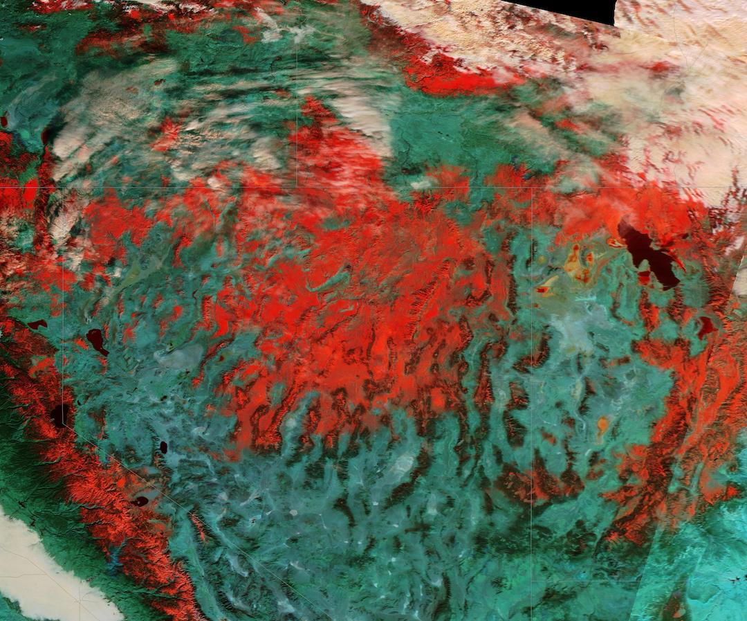
For scientists looking at false-color satellite imagery, however, reds and greens have nothing to do with Christmas, and everything to do with the reflectance of various features on Earth.
The Moderate Resolution Imaging Spectroradiometer (MODIS) on board NASA’s Terra satellite acquired this false-color of image of snow across the Western United States on December 21, 2020. This image uses blue and shortwave infrared light (MODIS bands 3,6,7) to differentiate the various states of water—liquid, snow, ice, and clouds. In this combination of bands, vegetation appears green while deserts are blue-green. Ice or snow appears bright red, liquid water looks dark red to black, and clouds may appear white or, if they contain ice crystals, will appear reddish-orange or peach.
This image is centered over the Great Basin in Nevada and Utah — an area made up of a series of depressions, flats, dry lakes, marshy salt pans and sinks, all scattered between ribbons of mountain ranges. Snow covers the northern section of the Great Basin, the Sierra Nevada mountains (west) and reaches east to Utah’s Great Salt Lake. Further south, mountainous deserts are colored blue-green. Peach-colored clouds in the north show the presence of ice while in the far southwest (lower left corner) a fog bank fills part of California’s Central Valley. Bright green vegetation lies between the fog and Sierra Nevada snow.
Image Facts
Satellite:
Terra
Date Acquired: 12/21/2020
Resolutions:
1km (196.7 KB), 500m (649.4 KB), 250m (1.9 MB)
Bands Used: 3,6,7
Image Credit:
MODIS Land Rapid Response Team, NASA GSFC
When Americans celebrate the Christmas holiday each December 25, they are likely to have their homes decorated with traditional “Christmas colors” – red and green. If you ask why these colors represent what is, for many, a high holy day, you are likely to garner answers that span a gamut from secular to religious. Kids may say green is for the Christmas tree and red stands for the bright nose of Santa’s lead reindeer, Rudolph. Christians may explain that the color of evergreen trees represents eternal life and hope, as the trees endure the harshest winters and remain alive and that red represents the blood of Christ, whose birth is celebrated on this day. Others speculate that the colors of the season come from the holly tree, whose bright red berries and stunning green foliage stand out beautifully against snow – and was used by ancient Romans to decorate their homes for Saturnalia, a celebration held on the shortest days of the year, from December 17-23. Then again, some historians claim that these colors became popular symbols of Christmas in America due to widespread advertising by the Coca-Cola company in the early 1930s. The ads highlighted the company’s green glass bottles of soda being held by a red-suited Santa and became, themselves, a symbol of an American Christmas.
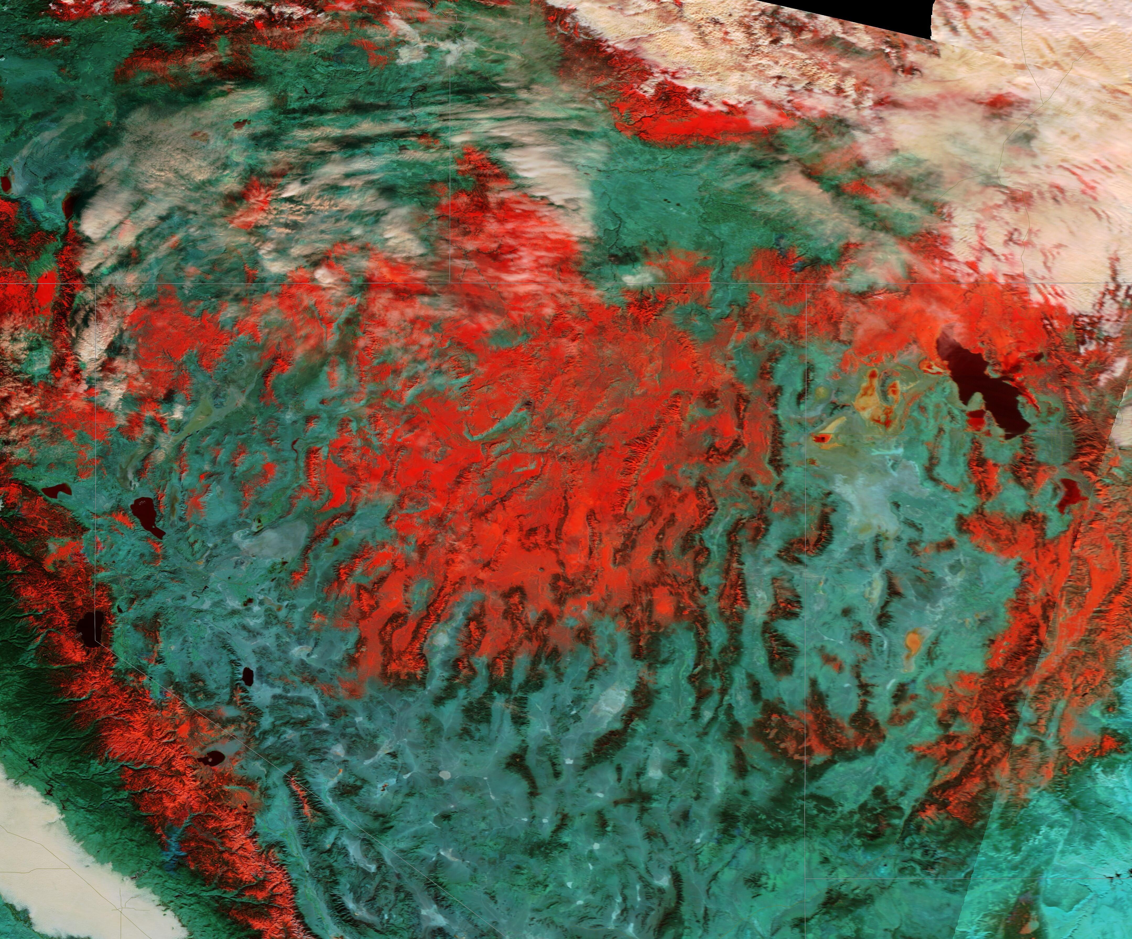
For scientists looking at false-color satellite imagery, however, reds and greens have nothing to do with Christmas, and everything to do with the reflectance of various features on Earth.
The Moderate Resolution Imaging Spectroradiometer (MODIS) on board NASA’s Terra satellite acquired this false-color of image of snow across the Western United States on December 21, 2020. This image uses blue and shortwave infrared light (MODIS bands 3,6,7) to differentiate the various states of water—liquid, snow, ice, and clouds. In this combination of bands, vegetation appears green while deserts are blue-green. Ice or snow appears bright red, liquid water looks dark red to black, and clouds may appear white or, if they contain ice crystals, will appear reddish-orange or peach.
This image is centered over the Great Basin in Nevada and Utah — an area made up of a series of depressions, flats, dry lakes, marshy salt pans and sinks, all scattered between ribbons of mountain ranges. Snow covers the northern section of the Great Basin, the Sierra Nevada mountains (west) and reaches east to Utah’s Great Salt Lake. Further south, mountainous deserts are colored blue-green. Peach-colored clouds in the north show the presence of ice while in the far southwest (lower left corner) a fog bank fills part of California’s Central Valley. Bright green vegetation lies between the fog and Sierra Nevada snow.
Image Facts
Satellite:
Terra
Date Acquired: 12/21/2020
Resolutions:
1km (196.7 KB), 500m (649.4 KB), 250m (1.9 MB)
Bands Used: 3,6,7
Image Credit:
MODIS Land Rapid Response Team, NASA GSFC
