
Images


February 22, 2021 - Water in the Etosha Pan
 Tweet
Tweet
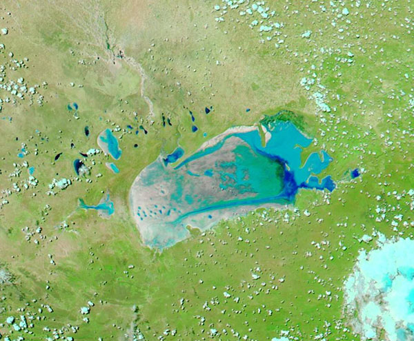
The Etosha Pan in northern Namibia has been called an “ephemeral wonder”. For much of the year, the large salt pan is bone dry, and winds pick up its dust and salt and spread it across the arid landscape. But in years when the wet season brings abundant rains, the large, shallow basin stands out as a temporary oasis.
After an extended dry season, rains came to the region in early 2021, filling streams and rivers with enough water to reach the inland salt pan. According to news reports, parts of northeastern, central, and southern parts of Namibia saw rainfalls double or triple the norm in January 2021. This followed a wet December, which brought about 25 percent more rain than normal. As of February 7, the wet season totals were the highest since 2010 and 2011.
The Moderate Resolution Imaging Spectroradiometer (MODIS) on NASA’s Terra satellite acquired a false-color image of the Etosha pan on February 19. 2021. The image combines visible and near-infrared light such that vegetation appears bright green and water is teal. Mineral salts appear white, except where they are moistened with water they may appear gray or light teal. Unvegetated land appears tan and high cloud, which contains ice or moisture, may be tinted with teal.
The Etosha Pan stretches roughly 130 kilometers by 50 kilometers (80 by 30 miles), though it is quite shallow. The basin is connected to hundreds of small streams and channels that start in Angola, but it takes a substantial amount of rain for water to move far enough through the system (seeping into the riverbeds along the way) to fill the pan. The most prominent tributary is the Ekuma River. Once that water arrives, the area becomes a haven for flamingos, pelicans, and other birds, as well as rhinos and impalas.
Image Facts
Satellite:
Terra
Date Acquired: 2/19/2021
Resolutions:
1km (92 KB), 500m (227.9 KB), 250m (358.4 KB)
Bands Used: 1,4,3
Image Credit:
MODIS Land Rapid Response Team, NASA GSFC
