
Images


February 23, 2021 - The Pineapple Express heads to the Pacific West Coast
 Tweet
Tweet
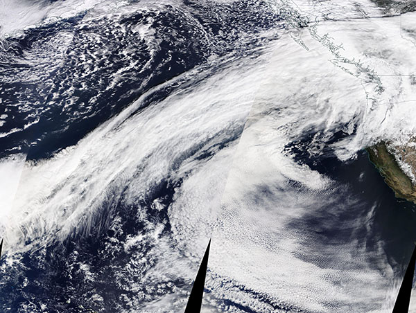
A dramatic true-color image of an atmospheric river flowing over the Pacific Ocean towards the United States’ Pacific Northwest was captured by the Moderate Resolution Imaging Spectroradiometer (MODIS) on board NASA’s Terra satellite on February 21, 2021. The system is bringing precipitation to coastal areas and the mountains of Washington and Oregon, triggering flood watches and increasing the risk for avalanches.
Atmospheric rivers, which are essentially jet streams of moist air, may stretch tens to hundreds of miles wide, and sometimes can carry an amount of water vapor equivalent to 7.5 to 15 times the flow at the mouth of the Mississippi River. They often occur of the west coast of North and South America and can be either a blessing—bringing much-needed rain in dry years—or a curse as they dump large amounts of water onto already-wet region.
The most common type of atmospheric river to impact the West Coast is known as the “Pineapple Express”. A Pineapple Express, such as this one, is created when moisture builds up in the tropical Pacific Ocean near Hawaii—where pineapples are common—and then charges like a rapid freight train across about 2,600 miles (4,180) of ocean to dump an impressive load of moisture on the U.S. and Canada’s West Coasts.
Image Facts
Satellite:
Terra
Date Acquired: 2/21/2020
Resolutions:
1km (4 MB),
Bands Used: 1,4,3
Image Credit:
MODIS Land Rapid Response Team, NASA GSFC
