Images
March 14, 2021 - A March Day across the Mid-Atlantic
Tweet
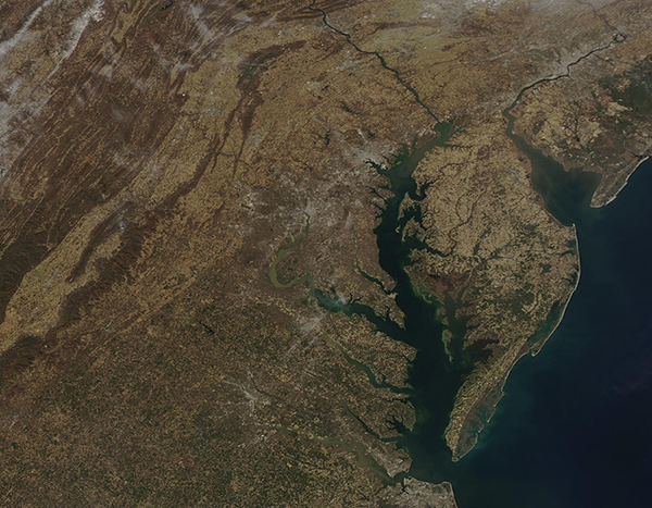
“It was one of those March days when the sun shines hot and the wind blows cold: when it is summer in the light and winter in the shade.” Those words were penned by Charles Dickens in 1861, as he described a certain London spring day in his book, Great Expectations. On March 10, 2021, the Moderate Resolution Imaging Spectroradiometer (MODIS) on board NASA’s Aqua satellite acquired a true-color image of just such a March day across the Mid-Atlantic United States—a day of hot sunshine and chilly winds.
The region was battered with a trio of winter storms through February, including a snow-and-ice-filled storm that swept the region February 15-20, a quick-striking nor’easter on February 7, and an intense nor’easter from January 31-February 3. As often happens in spring, the weather made an about-face in early March, with many states, including Maryland, Virginia, and the District of Columbia, reaching unusual high temperatures over several days. The day this image was captured, Baltimore, Maryland reached a high of 69˚F (20.5˚C) on March 10 – a warm 17˚F degrees over the historic average of 52˚F (11˚C). By the next day, the city was setting records, with a new high temperature of 79˚F (26˚F) degrees set on March 11 (the previous record was 75˚F (24˚C). Certainly, Baltimore experienced “summer in the sun” that day—as well as “winter in the shade”, logging a low of a cool 39˚F (3.9˚C) degrees. As often happens in March, the summer-like warmth will quickly give way to a winter-like chill. Baltimore highs are expected to only reach 44˚F (6.7˚C) on March 16, with the possibility of a touch of rain-snow mix on March 17.
The sunny weather allowed a sweeping clear-sky view that stretched from Virginia in the south to southern-most Pennsylvania and New Jersey in the north. A bit of northeastern West Virginia is captured in the west, Maryland in the north-central section, and Delaware in the east. The curving lines of the Appalachian Mountains decorates part of Virginia, Maryland, and West Virginia. Along the coast, the large Chesapeake Bay sits south of the smaller Delaware Bay. The Susquehanna River can be seen coursing through Pennsylvania and Maryland and into the Chesapeake Bay while the Delaware River flows into the northern Delaware Bay. Inland, gray pixels mark the footprint of humanity—towns, large roads, and major cities. A line of major cities has grown along the I-95 corridor. From south to north, they are: Richmond and Fredericksburg, Virginia; Washington DC (District of Columbia) on the Potomac River; Baltimore, Maryland on the Chesapeake Bay; and Philadelphia, Pennsylvania.
Image Facts
Satellite:
Aqua
Date Acquired: 3/10/2021
Resolutions:
1km (264.8 KB), 500m (719.3 KB), 250m (494 KB)
Bands Used: 1,4,3
Image Credit:
MODIS Land Rapid Response Team, NASA GSFC


