
Images


March 23, 2021 - The Great Lakes Straddle the Seasons
 Tweet
Tweet
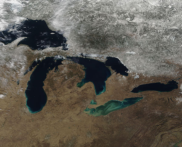
As winter gave way to spring, the Great Lakes appeared to straddle the seasons on March 21, 2021. The greens and tans of early spring colored the landscape south of the lakes, while winter’s snow clung to the ground on most of the northern coastlines. The Moderate Resolution Imaging Spectroradiometer (MODIS) on board NASA’s Terra satellite acquired this true-color image of the Great Lakes on that same day.
Each year, ice forms on the Great Lakes as frigid air temperatures take hold. As daylight lengthens and air temperatures warm in the spring, the lakes begin to shed their winter cover of ice. The ice season typically begins in December and ends in April, with an average maximum ice cover (measured between 1972-2020) measured at 53%. This year, however, the Great Lakes ice season was anything but typical.
This season started with unseasonably mild temperatures, as much as 8° Fahrenheit (4.5° Celsius) above normal through mid-January. Lake Erie—the shallowest of the Great Lakes and often the first to freeze—had one of the lowest amounts of ice on record for the time of year.
Early February brought a dramatic shift. Temperatures plummeted as low as 17° F below normal and blue lakes transformed into white lakes. But when temperatures climbed again in mid-February, the fragile ice cover broke up and melted as fast as it had formed. By February 20, the total ice cover across the lakes was near the season’s maximum extent of 46.5 percent. But by March 3, ice covered just 15 percent of the lake surfaces.
According to the U.S. National Weather Service Great Lakes Ice Outlook published on March 22, ice coverage on the Great Lakes remains limited. It is confined to the protected bays of the Upper Great Lakes, including Green Bay, the Straits of Mackinac, and northern and eastern portions of Georgian Bay. Lake Erie is essentially ice-free, with only small amounts of very localized ice lingering along parts of the lakeshore. With air temperatures forecast to remain normal to above normal across the region, ice coverage is expected to continue to decrease.
Image Facts
Satellite:
Terra
Date Acquired: 3/21/2021
Resolutions:
1km (610.7 KB), 500m (2 MB), 250m (4.6 MB)
Bands Used: 1,4,3
Image Credit:
MODIS Land Rapid Response Team, NASA GSFC
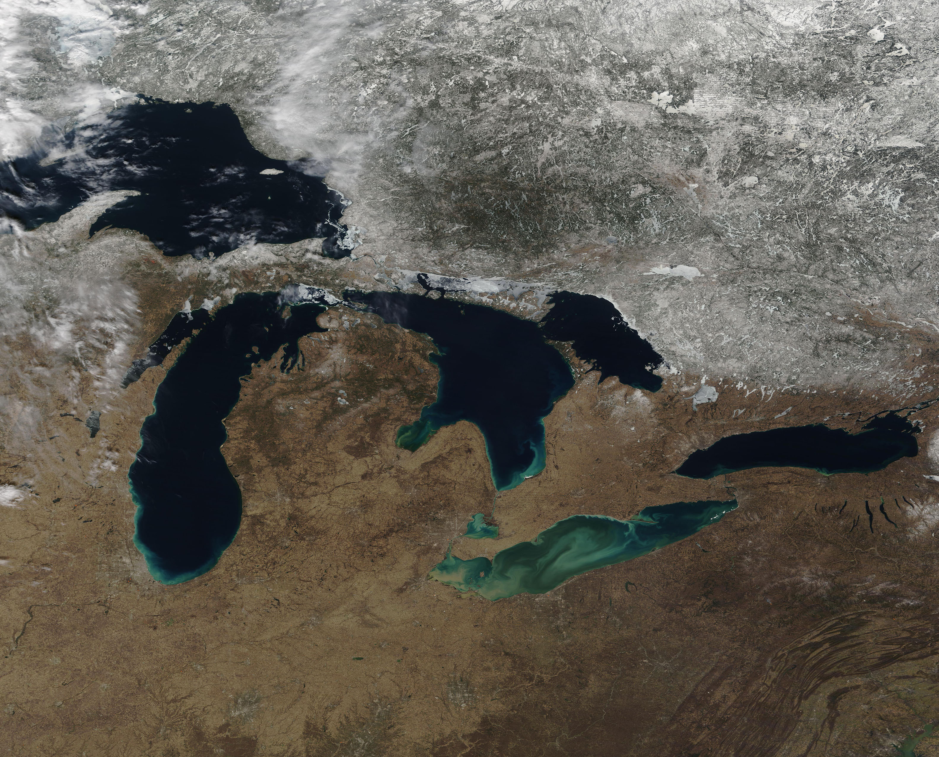
As winter gave way to spring, the Great Lakes appeared to straddle the seasons on March 21, 2021. The greens and tans of early spring colored the landscape south of the lakes, while winter’s snow clung to the ground on most of the northern coastlines. The Moderate Resolution Imaging Spectroradiometer (MODIS) on board NASA’s Terra satellite acquired this true-color image of the Great Lakes on that same day.
Each year, ice forms on the Great Lakes as frigid air temperatures take hold. As daylight lengthens and air temperatures warm in the spring, the lakes begin to shed their winter cover of ice. The ice season typically begins in December and ends in April, with an average maximum ice cover (measured between 1972-2020) measured at 53%. This year, however, the Great Lakes ice season was anything but typical.
This season started with unseasonably mild temperatures, as much as 8° Fahrenheit (4.5° Celsius) above normal through mid-January. Lake Erie—the shallowest of the Great Lakes and often the first to freeze—had one of the lowest amounts of ice on record for the time of year. Early February brought a dramatic shift. Temperatures plummeted as low as 17° F below normal and blue lakes transformed into white lakes. But when temperatures climbed again in mid-February, the fragile ice cover broke up and melted as fast as it had formed. By February 20, the total ice cover across the lakes was near the season’s maximum extent of 46.5 percent. But by March 3, ice covered just 15 percent of the lake surfaces.
According to the U.S. National Weather Service Great Lakes Ice Outlook published on March 22, ice coverage on the Great Lakes remains limited. It is confined to the protected bays of the Upper Great Lakes, including Green Bay, the Straits of Mackinac, and northern and eastern portions of Georgian Bay. Lake Erie is essentially ice-free, with only small amounts of very localized ice lingering along parts of the lakeshore. With air temperatures forecast to remain normal to above normal across the region, ice coverage is expected to continue to decrease.
Image Facts
Satellite:
Terra
Date Acquired: 3/21/2021
Resolutions:
1km (610.7 KB), 500m (2 MB), 250m (4.6 MB)
Bands Used: 1,4,3
Image Credit:
MODIS Land Rapid Response Team, NASA GSFC
