
Images


March 29, 2021 - Flooding in Australia
 Tweet
Tweet
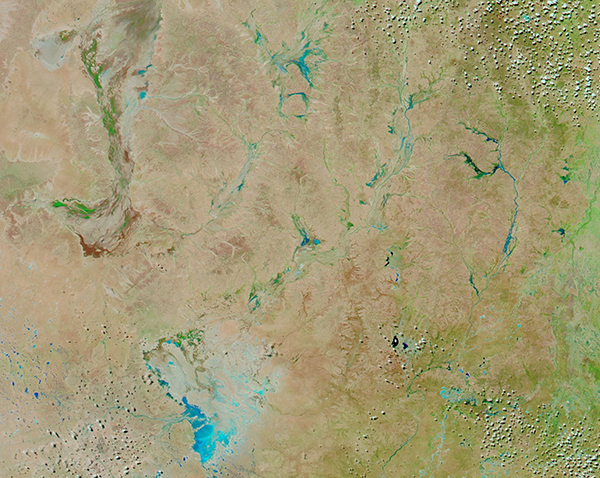
Persistent, heavy rain fell for several days in late summer 2021 in New South Wales and Queensland, Australia.
New South Wales has experienced the region’s worst flooding in six decades. The Australian Bureau of Meteorology reported that areas around Sydney and in the Hunter and Mid North Coast regions were drenched with 400 to 600 millimeters (16 to 24 inches) of rain across four days, with the most extreme totals approaching one meter. According to media reports, almost 100 mm (4 in) of rain had drenched the far outback town of Tibooburra in just 12 hours—a town whose long-term average rainfall in March is just 22 mm (0.9 in).
Further north, the Queensland Fire and Emergency Service (QFES) issued an alert for residents of Beaudesert after the Logan River reached major flood level due to heavy rainfall as 60 homes were isolated by flood waters and two persons were rescued. According to the Global Disaster Alert and Coordination System (GDACS), QFES warned of potential flooding along the Albert River in parts of the Scenic Rim Region on March 23.
On March 25, 2021, the Moderate Resolution Imaging Spectroradiometer (MODIS) on board NASA’s Aqua satellite acquired a false-color image of flooding in north-western New South Wales and south-western Queensland. Tibooburra, NSW, sits in the lower left corner of the image, not far from the large ephemeral lake that is now filled with water. Several lakes and rivers can be seen to be swollen with water. In this type of false color image (using bands 7,2,1), water appears electric blue, vegetation appears green, and open land varies between tan and brown.
While a single image can give an impressive view of an event such as a flood, sometimes even more information can be gained by comparing images acquired of the same area on different days. Thanks to the NASA Worldview App, we can easily view two false-color Aqua images taken of the same region after inundation (March 25) and just prior to the rainfall (March 6). To view the roll-over comparison, click
here.
Image Facts
Satellite:
Aqua
Date Acquired: 3/25/2021
Resolutions:
1km (344.9 KB), 500m (949.6 KB), 250m (553.2 KB)
Bands Used: 7,2,1
Image Credit:
MODIS Land Rapid Response Team, NASA GSFC
Persistent, heavy rain fell for several days in late summer 2021 in New South Wales and Queensland, Australia.
New South Wales has experienced the region’s worst flooding in six decades. The Australian Bureau of Meteorology reported that areas around Sydney and in the Hunter and Mid North Coast regions were drenched with 400 to 600 millimeters (16 to 24 inches) of rain across four days, with the most extreme totals approaching one meter. According to media reports, almost 100 mm (4 in) of rain had drenched the far outback town of Tibooburra in just 12 hours—a town whose long-term average rainfall in March is just 22 mm (0.9 in).
Further north, the Queensland Fire and Emergency Service (QFES) issued an alert for residents of Beaudesert after the Logan River reached major flood level due to heavy rainfall as 60 homes were isolated by flood waters and two persons were rescued. According to the Global Disaster Alert and Coordination System (GDACS), QFES warned of potential flooding along the Albert River in parts of the Scenic Rim Region on March 23.
On March 25, 2021, the Moderate Resolution Imaging Spectroradiometer (MODIS) on board NASA’s Aqua satellite acquired a false-color image of flooding in north-western New South Wales and south-western Queensland. Tibooburra, NSW, sits in the lower left corner of the image, not far from the large ephemeral lake that is now filled with water. Several lakes and rivers can be seen to be swollen with water. In this type of false color image (using bands 7,2,1), water appears electric blue, vegetation appears green, and open land varies between tan and brown.
While a single image can give an impressive view of an event such as a flood, sometimes even more information can be gained by comparing images acquired of the same area on different days. Thanks to the NASA Worldview App, we can easily view two false-color Aqua images taken of the same region after inundation (March 25) and just prior to the rainfall (March 6). To view the roll-over comparison, click here.
Image Facts
Satellite:
Aqua
Date Acquired: 3/25/2021
Resolutions:
1km (344.9 KB), 500m (949.6 KB), 250m (553.2 KB)
Bands Used: 7,2,1
Image Credit:
MODIS Land Rapid Response Team, NASA GSFC
