
Images


April 1, 2021 - Flooding in Tennessee
 Tweet
Tweet
Severe storms crossed Tennessee on March 27, 2021, battering the state with heavy rain and high wind, and sparking tornado and flood warnings. The deluge was so heavy that severe flash flooding was reported in several areas. On March 30, the Tennessee Emergency Management Agency (TEMA) reported that seven weather-related deaths had been confirmed. Flash Flood Watches continued across most of the state on that date and several highways continued to be closed due to high water. Shelters remained open in Campbell, Davidson, Hardeman, Rutherford, Sullivan, and Wilson counties.
The extreme weather was just part of a sweeping system that affected a swath from East Texas to Tennessee—the National Weather Service received reports of 16 tornados, 140 reports of large hail, and 100 reports of wind damage from the southeast from March 27-28. In Tennessee, the hardest-hit area appears to be Davidson County, where the city of Nashville reported substantial flooding, damage, and power outages after recording 7.01 inches from the afternoon of March 27 to the morning of March 28. This is the second-largest two-day rainfall total on record for that location.
Although rain has continued over parts of Tennessee through March 31, most rivers have crested and flooding risk is reduced. Colder weather has brought snow to some parts of the state as of March 31. According to the National Weather Service, Nashville Tennessee, as of 5:30 p.m. on March 31 the rainfall for the month has reached 12.28 inches. That’s just 0.08 inches short of the all-time high rainfall record for March (12.35 in) set in 1975.
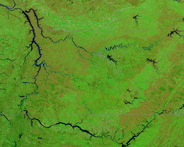
On March 29, the Moderate Resolution Imaging Spectroradiometer (MODIS) on board NASA’s Terra satellite acquired a false-color image centered on the state of Tennessee. Also visible are parts of southern Kentucky (north), Mississippi (southwest), and Alabama (south). This image uses both visible and infrared light (MODIS Bands 7,2,1) to highlights water. Here, water appears dark blue and contrasts sharply with vegetation (green) and open land (tan).
The major river visible is the Tennessee River, which rises in the east at the confluence of the French Broad and Holston Rivers in Knoxville. The Tennessee flows southwest, crossing into Alabama and traveling west to form part of the Alabama/Mississippi border before returning to Tennessee then flowing into Kentucky, where it meets the Ohio River. Most of the flood damage, however, was reported near Nashville, which sits along the Cumberland River. Dale Hollow Lake, which straddles Kentucky and Tennessee, can be seen in the upper right corner of the image. From Dale Hollow Lake, the Cumberland River meanders generally westward. Nashville sits near the center of the image, where the Cumberland narrows and just northeast of the large J Percy Priest Lake.
While this one image clearly illustrates high water in many areas, to gain a fuller sense of the change brought by the rain, it is helpful to compare a Terra MODIS image acquired prior to the flood with this one. Thanks to the NASA Worldview App, such comparisons are easy. To compare this image, acquired on March 29, with one acquired on March 7, click
here.
Image Facts
Satellite:
Terra
Date Acquired: 3/29/2021
Resolutions:
1km (397.4 KB), 500m (1 MB), 250m (651.3 KB)
Bands Used: 7,2,1
Image Credit:
MODIS Land Rapid Response Team, NASA GSFC
Severe storms crossed Tennessee on March 27, 2021, battering the state with heavy rain and high wind, and sparking tornado and flood warnings. The deluge was so heavy that severe flash flooding was reported in several areas. On March 30, the Tennessee Emergency Management Agency (TEMA) reported that seven weather-related deaths had been confirmed. Flash Flood Watches continued across most of the state on that date and several highways continued to be closed due to high water. Shelters remained open in Campbell, Davidson, Hardeman, Rutherford, Sullivan, and Wilson counties.
The extreme weather was just part of a sweeping system that affected a swath from East Texas to Tennessee—the National Weather Service received reports of 16 tornados, 140 reports of large hail, and 100 reports of wind damage from the southeast from March 27-28. In Tennessee, the hardest-hit area appears to be Davidson County, where the city of Nashville reported substantial flooding, damage, and power outages after recording 7.01 inches from the afternoon of March 27 to the morning of March 28. This is the second-largest two-day rainfall total on record for that location.
Although rain has continued over parts of Tennessee through March 31, most rivers have crested and flooding risk is reduced. Colder weather has brought snow to some parts of the state as of March 31. According to the National Weather Service, Nashville Tennessee, as of 5:30 p.m. on March 31 the rainfall for the month has reached 12.28 inches. That’s just 0.08 inches short of the all-time high rainfall record for March (12.35 in) set in 1975.
On March 29, the Moderate Resolution Imaging Spectroradiometer (MODIS) on board NASA’s Terra satellite acquired a false-color image centered on the state of Tennessee. Also visible are parts of southern Kentucky (north), Mississippi (southwest), and Alabama (south). This image uses both visible and infrared light (MODIS Bands 7,2,1) to highlights water. Here, water appears dark blue and contrasts sharply with vegetation (green) and open land (tan).
The major river visible is the Tennessee River, which rises in the east at the confluence of the French Broad and Holston Rivers in Knoxville. The Tennessee flows southwest, crossing into Alabama and traveling west to form part of the Alabama/Mississippi border before returning to Tennessee then flowing into Kentucky, where it meets the Ohio River. Most of the flood damage, however, was reported near Nashville, which sits along the Cumberland River. Dale Hollow Lake, which straddles Kentucky and Tennessee, can be seen in the upper right corner of the image. From Dale Hollow Lake, the Cumberland River meanders generally westward. Nashville sits near the center of the image, where the Cumberland narrows and just northeast of the large J Percy Priest Lake.
While this one image clearly illustrates high water in many areas, to gain a fuller sense of the change brought by the rain, it is helpful to compare a Terra MODIS image acquired prior to the flood with this one. Thanks to the NASA Worldview App, such comparisons are easy. To compare this image, acquired on March 29, with one acquired on March 7, click here.
Image Facts
Satellite:
Terra
Date Acquired: 3/29/2021
Resolutions:
1km (397.4 KB), 500m (1 MB), 250m (651.3 KB)
Bands Used: 7,2,1
Image Credit:
MODIS Land Rapid Response Team, NASA GSFC
