
Images


April 24, 2021 - Sunshine over Western Europe
 Tweet
Tweet
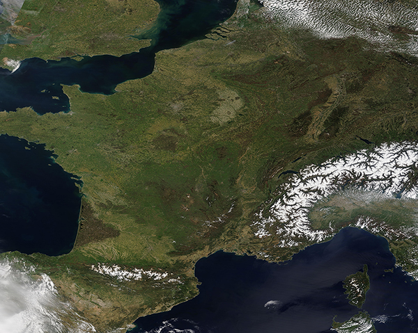
Sunny skies accentuated the verdant spring beauty of Western Europe on April 23, 2021. The Moderate Resolution Imaging Spectroradiometer (MODIS) on board NASA’s Terra satellite acquired a stunning, cloud-free, true-color image centered on France on that same day.
The darkest greens are created by coniferous forests, which retain their needles year-round. Deciduous forests, which are greening as leaves burst forth in the worming weather, are almost equally as dark as conifers. Agricultural lands and grasslands are painted in lighter greens. Large areas of human structures, such as cities and major roadways, are marked by gray pixels.
The contrast in colors of the land cover can be illustrated by finding the relatively small, nearly-round very dark green area just north of center in this image. These greens are an area dominated by conifer forest. Moving north, an arc of lighter green colors an agricultural area that is often used for winter crops, but also supports spring cropping and pasture. If viewed at high resolution (250 meters), its easy to see a patchwork of tan (open land), light green (new crops) and darker greens (older crops/trees) which is typical of farmland. A smudge of gray sits north of the agricultural arc. This is the city of Paris, home to more than 11 million people and the capital of France. At higher resolutions you can see the Seine River flowing through the city of Paris as well as the surrounding countryside.
Several European countries border France and can be seen in this image. Starting in the north and moving clockwise France borders: Belgium, Luxembourg, Germany, Switzerland, Italy, Monaco, the Mediterranean Sea, Spain, Andorra, the Bay of Biscay, and—across the English Channel—the United Kingdom.
Image Facts
Satellite:
Terra
Date Acquired: 4/23/2021
Resolutions:
1km (2.4 MB), 500m (6.9 MB), 250m (5.3 MB)
Bands Used: 1,4,3
Image Credit:
MODIS Land Rapid Response Team, NASA GSFC
