
Images


May 7, 2021 - Texas
 Tweet
Tweet
Sitting along the southern border of the United States and just north of Mexico, the state of Texas stretches across 268,820 square miles (696,241 square kilometers), capturing the title of the second-largest state in the country, following only Alaska. If Texas were a country, it would rank as the 40th-largest in the world, coming in slightly smaller than Morocco and just larger than Burma (Myanmar). In terms of population, Texas—with approximately 29.7 million inhabitants in 2021—comes in as the second most-populous state in the USA, falling behind only California (39.7 million inhabitants). If compared to countries, the population of Texas would bring it to 49th place, following Yemen (29.8 million) and leading Nepal (29.1 million).
Despite the popular Texan brag proclaiming “Everything is bigger in Texas”, Texas isn’t bigger than EVERYTHING. It is, however, much bigger than most things, including most states, many countries and, as any resident might quietly point out, it retains claiming rights to “big hats, big hair, and big attitudes”.
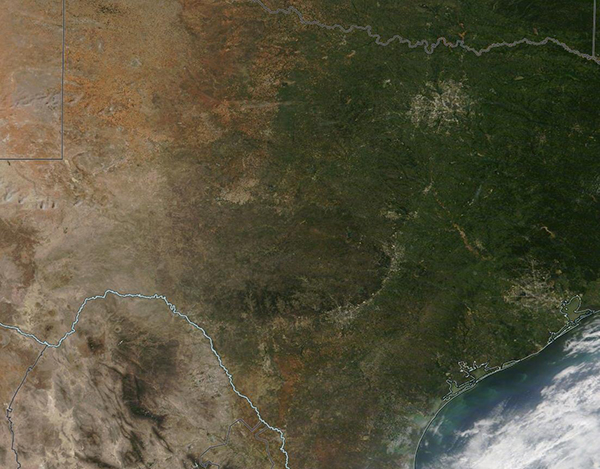
On May 5, 2021, the Moderate Resolution Imaging Spectroradiometer (MODIS) on board NASA’s Terra satellite acquired a true-color image that captures most of the landscape of the expansive state of Texas.
A white line has been added to the image to illustrate the border between Texas, USA, and Mexico. Gray lines mark borders between Texas and two adjacent states—Arizona to the west and Oklahoma to the north. In the southeast, Texas borders the Gulf of Mexico. Long, narrow barrier islands line the Texas coast, forming protective bays between the Gulf and the mainland.
Cement-colored pixels mark cities and human construction. Along the coast, Houston dominates as the largest city, sprawling across the greenness of pine forests and swamps that dominate the coastal landscape of the state. Northwest of Houston, a large area of gray pixels marks the Dallas-Fort Worth metroplex.
Moving west and northwest of Houston, the cities of San Antonio and Austin are tucked near the feet of a steep rise called the Balcones Escarpment. This geological fault zone, stretching across several miles, creates balcony-like hills that rise sharply above the coastal plain. The Balcones form the southern and eastern edge of the Edwards Plateau. This area marks changes in topography, geology, ecology, and climate from flat and humid coastal wetlands to rocky hills with woodlands (dark green in the image). The area is known regionally as the Texas Hill Country.
The Interior Lowlands (also called the North Central Plains) cover the northeastern part of Texas, including Dallas-Fort Worth. This region features rolling grasslands and limestone and has a lower humidity than most of the rest of the state. The Great Plains sit on the west of the North-Central Plain, covering most of the Texas Panhandle, and stretch westward to the Basin and Range region. Flat and generally free of vegetation, the Basin and Range region is arid, with hot summers and cold winters.
Image Facts
Satellite:
Terra
Date Acquired: 5/5/2021
Resolutions:
1km (142.2 KB), 500m (530.6 KB), 250m (1.8 MB)
Bands Used: 1,4,3
Image Credit:
MODIS Land Rapid Response Team, NASA GSFC
Sitting along the southern border of the United States and just north of Mexico, the state of Texas stretches across 268,820 square miles (696,241 square kilometers), capturing the title of the second-largest state in the country, following only Alaska. If Texas were a country, it would rank as the 40th-largest in the world, coming in slightly smaller than Morocco and just larger than Burma (Myanmar). In terms of population, Texas—with approximately 29.7 million inhabitants in 2021—comes in as the second most-populous state in the USA, falling behind only California (39.7 million inhabitants). If compared to countries, the population of Texas would bring it to 49th place, following Yemen (29.8 million) and leading Nepal (29.1 million). Despite the popular Texan brag proclaiming “Everything is bigger in Texas”, Texas isn’t bigger than EVERYTHING. It is, however, much bigger than most things, including most states, many countries and, as any resident might quietly point out, it retains claiming rights to “big hats, big hair, and big attitudes”.
On May 5, 2021, the Moderate Resolution Imaging Spectroradiometer (MODIS) on board NASA’s Terra satellite acquired a true-color image that captures most of the landscape of the expansive state of Texas.
A white line has been added to the image to illustrate the border between Texas, USA, and Mexico. Gray lines mark borders between Texas and two adjacent states—Arizona to the west and Oklahoma to the north. In the southeast, Texas borders the Gulf of Mexico. Long, narrow barrier islands line the Texas coast, forming protective bays between the Gulf and the mainland.
Cement-colored pixels mark cities and human construction. Along the coast, Houston dominates as the largest city, sprawling across the greenness of pine forests and swamps that dominate the coastal landscape of the state. Northwest of Houston, a large area of gray pixels marks the Dallas-Fort Worth metroplex.
Moving west and northwest of Houston, the cities of San Antonio and Austin are tucked near the feet of a steep rise called the Balcones Escarpment. This geological fault zone, stretching across several miles, creates balcony-like hills that rise sharply above the coastal plain. The Balcones form the southern and eastern edge of the Edwards Plateau. This area marks changes in topography, geology, ecology, and climate from flat and humid coastal wetlands to rocky hills with woodlands (dark green in the image). The area is known regionally as the Texas Hill Country.
The Interior Lowlands (also called the North Central Plains) cover the northeastern part of Texas, including Dallas-Fort Worth. This region features rolling grasslands and limestone and has a lower humidity than most of the rest of the state. The Great Plains sit on the west of the North-Central Plain, covering most of the Texas Panhandle, and stretch westward to the Basin and Range region. Flat and generally free of vegetation, the Basin and Range region is arid, with hot summers and cold winters.
Image Facts
Satellite:
Terra
Date Acquired: 5/5/2021
Resolutions:
1km (142.2 KB), 500m (530.6 KB), 250m (1.8 MB)
Bands Used: 1,4,3
Image Credit:
MODIS Land Rapid Response Team, NASA GSFC
