
Images


June 20, 2021 - Burn Scars in Montana
 Tweet
Tweet
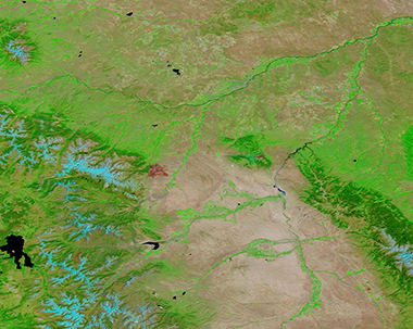
On the afternoon of June 13, 2021, a blaze was spotted burning in sage and grass about 7 miles south of the town of Red Lodge, Montana and only about 1 mile north of the border with Wyoming. Seated along the Beartooth Mountains, Red Lodge is the county seat of Carbon County and home to slightly more than 2,000 people. It has been called the Gateway to Yellowstone National Park, so tourism can swell the town’s population, especially during summer vacations and winter ski season.
Only three days after first ignition, the Robertson Draw Fire had exploded to a formidable blaze, reaching 24,470 acres in size by June 16, with 21 structures reported damaged. As of the morning of June 19, the fire had grown—but only slightly—with estimated burn area at 27,556 acres. With 276 personnel working the fire, good progress was made on fighting much of the fire over the last 48 hours, especially along the eastern edge. According to Inciweb Incident Information system, as of the morning of June 19 the fire was still considered to be zero percent contained. The fire was human-caused.
On June 16, the Moderate Resolution Imaging Spectroradiometer (MODIS) acquired a false-color image designed to highlight the area burned by the Robertson Draw Fire. This imaging technique does not look at thermal anomalies and thus there are no red “hot spots” to mark actively burning fire as can be seen with some MODIS images. Instead, it uses a combination of infrared and visible light (Bands 7-2-1) that helps differentiate vegetation (bright green) from freshly-burned soil, which appears brick red. Lakes and rivers appear blue while open land looks tan. Snow, such as seen atop the mountains west of the burn scar (area burned), appears electric blue.
There are no boundary lines overlain on this image to delineate the boundary between Montana (north) and Wyoming (south). The Robertson Draw Fire as approached close to the border, so the southern edge of the burn scar sits slightly more than 0.6 miles into Montana. The U-shaped Buffalo Bill Reservoir in Cody, Wyoming can be seen south of the burn scar and the large Yellowstone Lake sits in Teton County, Wyoming to the west of Robertson Draw Fire.
Image Facts
Satellite:
Terra
Date Acquired: 6/16/2021
Resolutions:
1km (187.3 KB), 500m (478.9 KB), 250m (267.9 KB)
Bands Used: 7,2,1
Image Credit:
MODIS Land Rapid Response Team, NASA GSFC
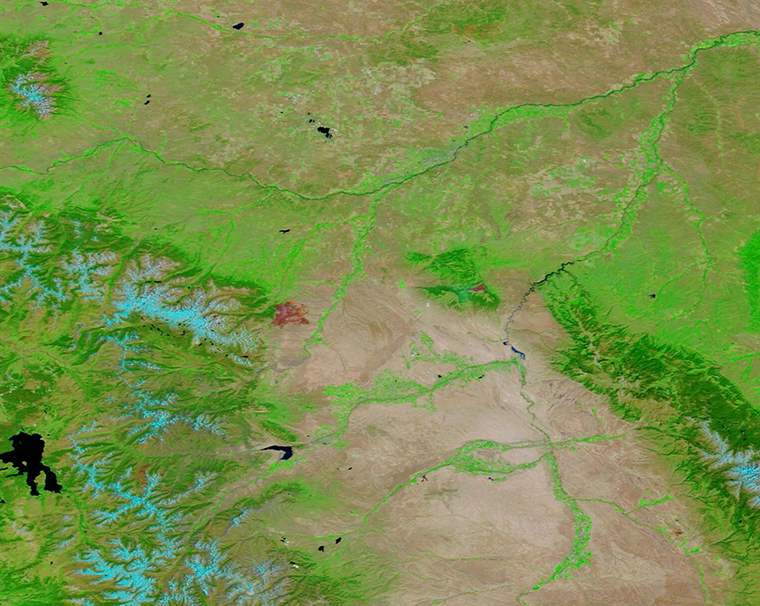
