
Images


April 28, 2024 - Iceland
 Tweet
Tweet
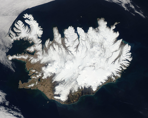
The nation of Iceland is located just south of the Arctic Circle and tucked between Greenland and the rest of Europe, making it the westernmost country in Europe. True to its name, the country is rich in year-round ice, with more land covered by glaciers on this Kentucky-sized island than in all continental Europe. It is also a country rich in volcanic activity, thanks to its location straddling a mid-ocean ridge between the North American and Eurasian tectonic plates, which are slowly spreading apart.
The Moderate Resolution Imaging Spectroradiometer (MODIS) on NASA’s Aqua acquired a true-color image a sunny spring day in Iceland on April 22, 2024.
Although warming weather and lengthening days have exposed open ground along the southwestern coastal region, snow still clings to most of the island, hiding the exact boundaries of the four permanent ice caps. Two ice caps, Langjokull and Hofsjokull are located in the interior west. Myrdalsjokull sits on the southern coast, and Vatnajokull can be found on the eastern coast. Vatnajokull is the largest of the four, and it rests on top of three active volcanoes.
The most recent volcanic activity has taken place on the Reykjanes peninsula, which protrudes into the North Atlantic Ocean from the southwestern side of the island. Four volcanic events have occurred near the town of Grindavík since December 2023, each sending lava flows from fissures in the area. The most recent eruption began on March 16, 2024, and lasted at least two weeks.
Image Facts
Satellite:
Aqua
Date Acquired: 4/22/2024
Resolutions:
1km (222.7 KB), 500m (661.7 KB), 250m (1.7 MB)
Bands Used: 1,4,3
Image Credit:
MODIS Land Rapid Response Team, NASA GSFC
