
Images


May 4, 2024 - Tropical Cyclone Hidaya off Tanzania
 Tweet
Tweet
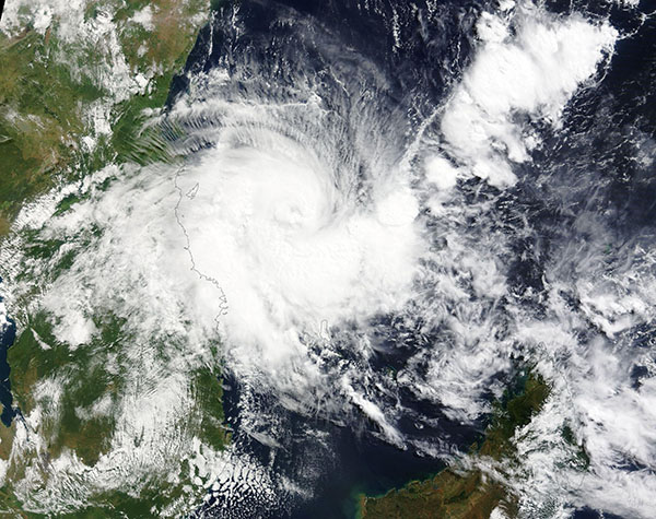
Tropical Cyclone Hidaya formed on May 1, 2024, over the Indian Ocean north of Madagascar. It was moving westward towards a portion of eastern Tanzania that had been struck by landslides and flooding from heavy rain in April.
At 11:00 a.m. EDT (1500 UTC) on May 3, the Joint Typhoon Warning Center (JTWC) advised that the storm was carrying maximum sustained winds of 86 mph (139 km/h) with gusts to 103.6 mph (166.7 km/h). That is the equivalent of a Category 1 hurricane on the Saffir-Simpson Hurricane Wind Scale. It was located about 208 miles (334.7 km) east-southeast of Dar Est Salaam, Tanzania and was tracking west-northwest.
Tropical Cyclone Hidaya has broken a new record as the most intense tropical cyclone in this region in the historical database, according to the JTWC advisory. It reached peak strength earlier in the day at 92 mph (148 km/h), before facing increasingly unfavorable conditions. The JTWC forecasts that Hidaya will continue to weaken before making landfall south of Dar Es Salaam on May 4. It is expected to dissipate inland after that time.
The Moderate Resolution Imaging Spectroradiometer (MODIS) on NASA’s Terra satellite acquired a true-color image of Tropical Cyclone Hidaya on May 3. At that time, the asymmetric storm had a cloud-filled center with leading rain bands covering most of eastern Tanzania, the Comoro Islands, and part of northern Mozambique.
Image Facts
Satellite:
Terra
Date Acquired: 5/3/2024
Resolutions:
1km (665.2 KB), 500m (2.1 MB), 250m (5.8 MB)
Bands Used: 1,4,3
Image Credit:
MODIS Land Rapid Response Team, NASA GSFC
