Images
October 1, 2024 - Remnants of Helene Hang Over the United States
Tweet
Hurricane Helene formed off the Yucatan Peninsula and intensified as it approached Florida’s Big Bend region, ultimately making landfall as a Category 4 storm at 11:10 p.m. EDT on September 26, 2024. Plowing ashore with maximum sustained winds of 140 miles per hour (225 km/h), the massive hurricane not only flattened parts of Florida, but it also carried convective bands that stretched more than 800 miles northward, triggering record-setting rainfall, landslides, and severe flooding across much of the Southeast and Appalachia.
The hurricane was traveling quickly forward, at about 20-30 miles per hour, as it came ashore, according to the National Weather Service (NWS). Even though maximum wind speeds dropped quickly over land, this fast forward dash meant that hurricane-force winds spread across the Southeast and tropical-storm-force winds pushed into the Tennessee and Ohio Valleys by September 27. By that same afternoon, as the center crossed over the Kentucky line, Helene became post-tropical—but was in no hurry to give up its widespread impact.
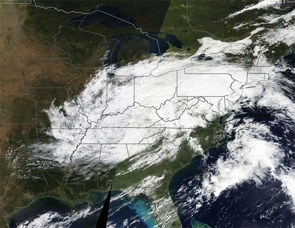
On September 29, the Moderate Resolution Imaging Spectroradiometer (MODIS) on NASA’s Terra satellite acquired this true-color image of the remnants of Hurricane Helene hanging over the United States. The clouds stretch from northern Mississippi and Alabama northward to southern Michigan, New York, and even Canada.
The cloudy remnants continued to drop rain throughout the expansive region through September 30, even after the initial drenching that spurred devastating flooding in North Carolina and East Tennessee lightened and floodwater began to recede. Continued rain is forecast through the first days of October for most of the region.
Image Facts
Satellite:
Terra
Date Acquired: 9/29/2024
Resolutions:
1km (1.4 MB), 500m (3.6 MB),
Bands Used: 1,4,3
Image Credit:
MODIS Land Rapid Response Team, NASA GSFC


