Images
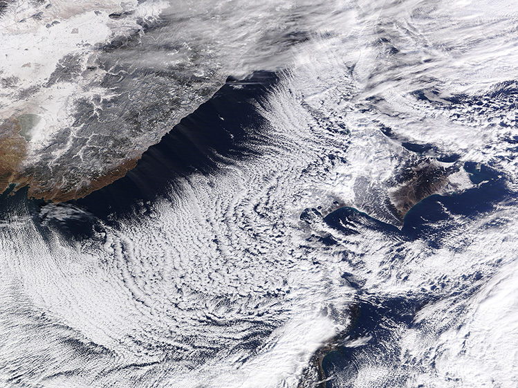
December 24, 2024 - Cloud Streets between Russia and Japan
Tweet
A cold snap in Eastern Russia sent daily high temperatures plummeting to 14 to 16°F (-10 to -8.9°C) in Primorsky Krai on December 18, 2024. Overnight lows on December 17-18 reached a frigid -4°F (-8.9°C), turning morning breezes blowing from mainland Russia over the Sea of Japan (East Sea) into cloud-making machines.
On December 18, the Moderate Resolution Imaging Spectroradiometer (MODIS) on NASA’s Terra satellite captured this true-color image of linear rows of cumulus clouds stretching over the sea between Russia and Japan. The rows line up with the direction of the wind and begin to form off the coast of Russia.
Cloud streets form when cold air blows over warmer waters and a warmer air layer (temperature inversion) rests over the top of both. The comparatively warm water gives up heat and moisture to the cold air above, and columns of heated air (thermals) naturally rise through the atmosphere. The temperature inversion acts like a lid. When the rising thermals hit it, they roll over and loop back on themselves, creating parallel cylinders of rotating air. As this happens, the moisture cools and condenses into flat-bottomed, fluffy-topped cumulus clouds that line up parallel to the direction of the prevailing winds. Such cloud streets are common in this area in the winter.
Image Facts
Satellite:
Terra
Date Acquired: 12/18/2024
Resolutions:
1km (1.2 MB), 500m (3.7 MB), 250m (5.9 MB)
Bands Used: 1,4,3
Image Credit:
MODIS Land Rapid Response Team, NASA GSFC


