Images
November 21, 2024 - Bomb Cyclone Batters the Western United States
Tweet
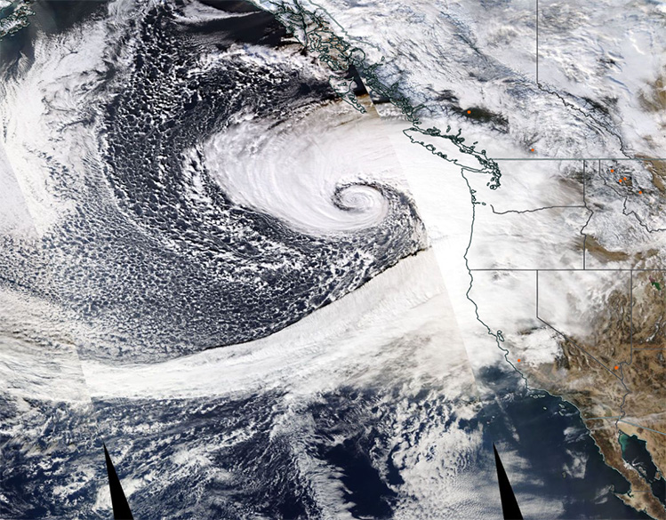
A strong extratropical cyclone slammed the Western United States on November 19, 2024, bringing damaging winds, rain, and snow to the region. The storm knocked over trees and left nearly 600,000 people without power in Washington state on November 20, according to news reports.
The Moderate Resolution Imaging Spectroradiometer (MODIS) on NASA’s Aqua satellite acquired this true-color image of the massive storm on November 19. The image shows the center of circulation over the Pacific Ocean west of the Pacific Northwest and a long tail of cloud curving into the center.
The clouds stretch far over the Pacific Ocean and are caused by an “atmospheric river”—a long, narrow band in the atmosphere that can carry an extreme amount of water. When the band moves over land, it is expected to be released as heavy rain and snow. Forecasters expect that this long-duration atmospheric river will park over Northern California and southern Oregon through November 22. The Weather Channel estimates that these areas could see rainfall totals of 12-18 inches (30-47 cm). White-out conditions were reported in the mountains of Washington on November 20.
Extratropical cyclones are large rotating weather systems that occur in the midlatitudes (generally more than 30° latitude away from the equator). Mature extratropical cyclones like this often feature comma-shaped cloud patterns that are the product of “conveyor belt” circulation. Heavy precipitation is often present near the low-pressure head of the comma.
On the evening of November 19, the storm’s central pressure dropped to levels on par with a storm in October 2021, which saw the lowest pressure in about 50 years of records for that region, according to Chris Dolce, a meteorologist at The Weather Channel. The pace of the storm’s intensification was more than double the criteria for bombogenesis—a popular term that describes a midlatitude cyclone that rapidly intensifies into a “bomb cyclone.”
The plunging atmospheric pressure in the center of the storm caused winds to increase quickly on November 19. The National Weather Service in Seattle reported wind gusts of up to 77 miles (124 kilometers) per hour in the mountains southeast of Seattle.
The cyclone kicked off a long-duration atmospheric river that forecasters expect will park over Northern California and southern Oregon through November 22. The National Weather Service estimates that these areas could see rainfall totals of 12 to 16 inches (30 to 41 centimeters) over the duration of the storm.
Image Facts
Satellite:
Aqua
Date Acquired: 11/19/2024
Resolutions:
1km (541.8 KB), 500m ( B), 250m ( B)
Bands Used: 1,4,3
Image Credit:
MODIS Land Rapid Response Team, NASA GSFC


