
Images


February 6, 2016 - Lake Poop¾
 Tweet
Tweet
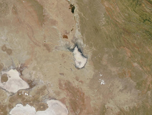
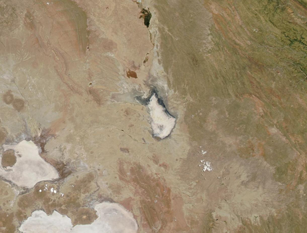
Once BoliviaÆs second-largest lake and a profitable fishery, Lake Poop¾ now resembles the dry, white salt flats that lie less than 100 mi (161 km) away.
The Moderate Resolution Imaging Spectroradiometer (MODIS) aboard NASAÆs Terra satellite captured this true-color image on January 22, 2016. Lake Poop¾ is located in the center of the image, with the nearly dry bed of the Desaguadero River at the northern tip. Two salt flats can be seen in the southwest: Salar de Coipasa and Salar de Uyuni. Salar de Uyuni is the more southerly of the two.
In a typical year, the water level in Lake Poop¾ drops to some degree during the dry season. However, the lake becomes refreshed during the wet season (December through March) by direct rainfall and via inflow from the Desaguadero River. Despite being well into the 2015-2016 wet season, the lake remains dry.
By mid-December, 2015, news agencies reported that Lake Poop¾ had essentially dried up. The reports blamed recurrent drought and the diversion of the lakeÆs water sources for mining and agriculture. On December 19 the government of the Bolivian province of Oruro issued a declaration of natural disaster due to the state of Lake Poop¾.
The loss of the lake would affect the economy of eight municipalities in the area. It also has affected almost 200 species of birds, mammals, fish and reptiles that once called the lake home. The disaster declaration aids in the mobilization of funds and manpower to try to improve the situation. According to news reports of AgenciaEFE, the Bolivian government has estimated that an investment of the equivalent to about 114 million US dollars would be necessary to save the lake.
Image Facts
Satellite:
Terra
Date Acquired: 1/22/2016
Resolutions:
1km (71.6 KB), 500m (181.2 KB), 250m (122.8 KB)
Bands Used: 1,4,3
Image Credit:
Jeff Schmaltz, MODIS Land Rapid Response Team, NASA GSFC
