Images
December 2, 2021 - Tropical Storm Nyatoh
Tweet
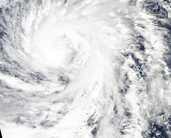
On December 1, 2021, the Moderate Resolution Imaging Spectroradiometer (MODIS) on board NASA’s Aqua satellite acquired a true-color image of Tropical Storm Nyatoh spinning over the western Pacific Ocean. About the time the image was captured, Nyatoh carried maximum sustained winds of 70 mph (115 km/h) and was moving towards the northwest at 9 mph (14.5 km/h). It was located about 847 miles (1363 km) from Davao City, Philippines. The large storm, which had reached tropical storm status on November 28, sported a cloud-filled center of circulation and was strengthening.
By 0300 UTC on December 2 (10:00 p.m. EST on December 1), Nyatoh had become a Typhoon. At that time, the Joint Typhoon Warning Center (JTWC) advised that the storm was carrying maximum sustained winds of 92 mph (148 km/h) with gusts up to 115 mph (185 km/h). This would place Typhoon Nyatoh as a strong Category 1 storm on the Saffir-Simpson Hurricane Wind Scale.
Typhoon Nyatoh is expected to continue to strengthen over open ocean for the next 24 hours when the JTWC expects it to meet strong vertical wind shear, which will turn the storm sharply southward. The unfavorable conditions are likely to cause Nyatoh to weaken quickly, but various models are not in complete agreement on the timeframe. No hazards to land are anticipated from this system.
Image Facts
Satellite:
Aqua
Date Acquired: 12/1/2021
Resolutions:
1km (302 KB), 500m (879.7 KB), 250m (2.4 MB)
Bands Used: 1,4,3
Image Credit:
MODIS Land Rapid Response Team, NASA GSFC


