
Images


May 14, 2022 - Romania in Springtime
 Tweet
Tweet
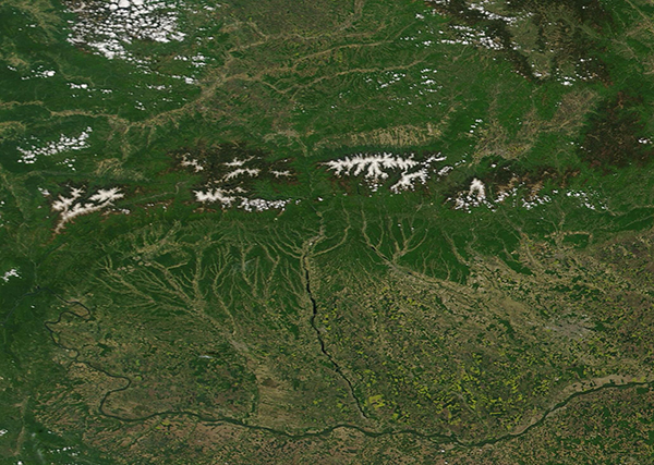
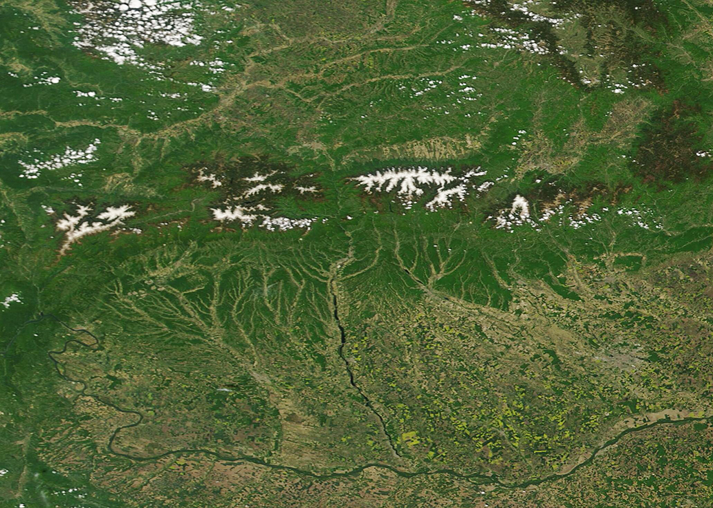
On May 12, 2022, the Moderate Resolution Imaging Spectroradiometer (MODIS) on board NASA’s Terra satellite acquired a true-color image of an idyllic spring day in Romania.
Located in southeastern Europe, Romania enjoys a varied landscape that includes lofty mountains, hilly plateaus, wide plains, fertile river valleys and, in the east and out of view of this image, beaches along the Black Sea. Coursing from west to east along the center of this image are the Southern Carpathian Mountains, which are also called the Transylvanian Alps. Snow and ice cap the highest elevations, which reach up to more than 8,200 feet (2,500 meters) high. The mountains are covered with deep conifers as well as freshly-leafing deciduous trees, which combine to coat the Southern Carpathians in glorious shades of green. Forests rich in oak and beech trees also cover the foothills, especially at elevations between 1,000 and 2,600 feet (300-800 meters).
On the southern side of the mountains, river valleys appear light green, suggesting grasslands or farmlands. Smaller rivers flow downhill to combine, creating larger rivers and wider valleys. The largest river that rises in the Southern Carpathians and flows roughly southward is the Olt. Rising in the mountains and ending as it spills in the Danube, the Olt River flows for about 382 miles (615 km) long, earning it the distinction of being the longest river flowing entirely inside Romania. The curving river seen near the bottom of the image is the Danube, which flows through or forms the borders of ten countries on its course from its source in the Black Forest of Germany en route to the Black Sea. Most of the portion of the Danube seen here forms the border between Romania (north) and Bulgaria (south).
Image Facts
Satellite:
Terra
Date Acquired: 5/12/2022
Resolutions:
1km (293.3 KB), 500m (774.1 KB), 250m (1.7 MB)
Bands Used: 1,4,3
Image Credit:
MODIS Land Rapid Response Team, NASA GSFC
