
Images


October 8, 2024 - Shrinking Caspian Sea


September 29, 2024
September 29, 2006
Tweet
The Caspian Sea is the largest brackish-water lake on Earth, spanning about 143,200 square miles (371,000 square kilometers)—an area only slightly smaller than the U.S. state of Montana. The long, narrow lake stretches about 750 miles (1,200 km) from north to south but averages only about 200 miles (320 km). Five countries share the shoreline: Kazakhstan in the northeast, Turkmenistan in the southeast, Iran in the south, Azerbaijan in the southwest, and Russia in the northwest.
Recently, all of these countries—as well as environmentalists and scientists worldwide—have raised concerns about the rapidly shrinking sea. An article published on October 1, 2024, quotes an Iranian Environmental Protection Organization official as saying, “Our shores have experienced significant retreat, raising concerns that our facilities and ports could be in jeopardy.” On August 19, Reuters reported that the President of Azerbaijan had met with the Russian President over concerns about “catastrophic” shrinking of the Caspian Sea. And on May 15, the Voice of America published an article that highlighted the impact of the shrinking sea on residents of Aqtau, a port city in Khazakstan. In 2023, the city officials declared a state of emergency over declining water levels, while the Kazakh Ministry of Environment said the situation was "critical."
Early signs of the Caspian Sea’s shrinkage appeared in the mid-2000s, but the rate appears to be increasing. According to a study published in Environmental Research Letters in August 2021, scientists projected that by 2100, water levels could drop by an additional 8 – 20 meters (26 to 98 feet)—and that was the loss brought about by a warming climate alone. Their models projected an additional loss of 7 meters (23 feet) due to diversion of water for human activity.
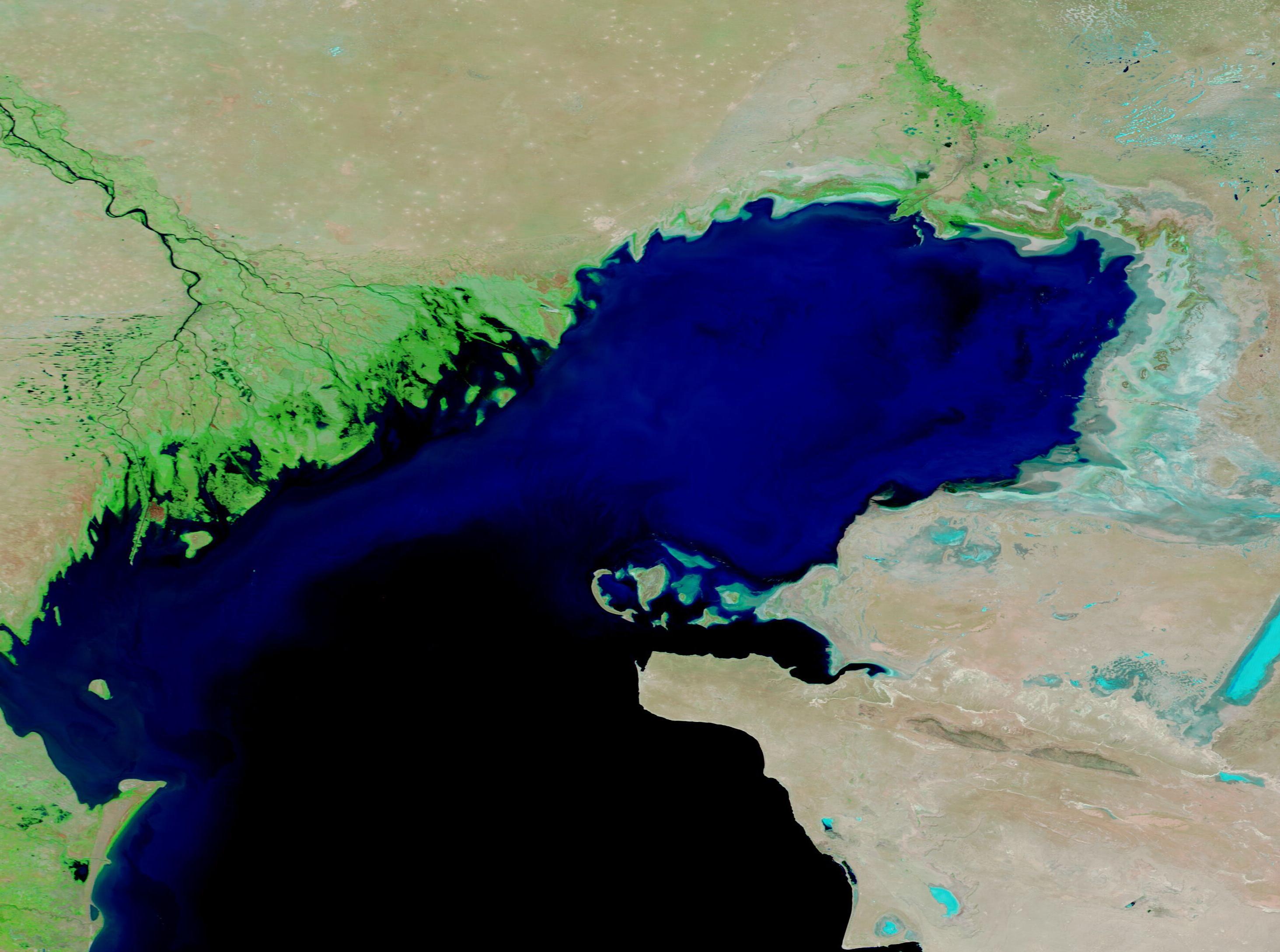
The shrinking of the Caspian Sea is easily visible in satellite imagery. To illustrate the change, we can compare two false-color images acquired by the Moderate Resolution Imaging Spectroradiometer (MODIS) eighteen years apart. The top image was acquired on September 29, 2024, and the second, which can be viewed by clicking on the date, was acquired on September 29, 2006.
This type of false-color image helps separate water (blue) from vegetation (bright green). Highly reflective mineral crusts may either appear white or bright blue. Clicking between the two images makes it obvious that the Caspian Sea was notably larger in 2006. Three rivers are prominent, the Volga (northwest), the Ural (northeast), and the Embe (east). Clicking on the 2024 image, it’s immediately notable that the northeastern end of the Caspian Sea has clearly retreated, leaving behind a mineral crust. The Embe river is no longer visible, although water still courses through the Volga and Ural Rivers.
Image Facts
Satellite:
Terra
Date Acquired: 9/29/2024
Resolutions:
1km (108 KB), 500m (244 KB), 250m (472.4 KB)
Bands Used: 7,2,1
Image Credit:
MODIS Land Rapid Response Team, NASA GSFC
September 29, 2024 September 29, 2006
The Caspian Sea is the largest brackish-water lake on Earth, spanning about 143,200 square miles (371,000 square kilometers)—an area only slightly smaller than the U.S. state of Montana. The long, narrow lake stretches about 750 miles (1,200 km) from north to south but averages only about 200 miles (320 km). Five countries share the shoreline: Kazakhstan in the northeast, Turkmenistan in the southeast, Iran in the south, Azerbaijan in the southwest, and Russia in the northwest.
Recently, all of these countries—as well as environmentalists and scientists worldwide—have raised concerns about the rapidly shrinking sea. An article published on October 1, 2024, quotes an Iranian Environmental Protection Organization official as saying, “Our shores have experienced significant retreat, raising concerns that our facilities and ports could be in jeopardy.” On August 19, Reuters reported that the President of Azerbaijan had met with the Russian President over concerns about “catastrophic” shrinking of the Caspian Sea. And on May 15, the Voice of America published an article that highlighted the impact of the shrinking sea on residents of Aqtau, a port city in Khazakstan. In 2023, the city officials declared a state of emergency over declining water levels, while the Kazakh Ministry of Environment said the situation was "critical."
Early signs of the Caspian Sea’s shrinkage appeared in the mid-2000s, but the rate appears to be increasing. According to a study published in Environmental Research Letters in August 2021, scientists projected that by 2100, water levels could drop by an additional 8 – 20 meters (26 to 98 feet)—and that was the loss brought about by a warming climate alone. Their models projected an additional loss of 7 meters (23 feet) due to diversion of water for human activity.
The shrinking of the Caspian Sea is easily visible in satellite imagery. To illustrate the change, we can compare two false-color images acquired by the Moderate Resolution Imaging Spectroradiometer (MODIS) eighteen years apart. The top image was acquired on September 29, 2024, and the second, which can be viewed by clicking on the date, was acquired on September 29, 2006.
This type of false-color image helps separate water (blue) from vegetation (bright green). Highly reflective mineral crusts may either appear white or bright blue. Clicking between the two images makes it obvious that the Caspian Sea was notably larger in 2006. Three rivers are prominent, the Volga (northwest), the Ural (northeast), and the Embe (east). Clicking on the 2024 image, it’s immediately notable that the northeastern end of the Caspian Sea has clearly retreated, leaving behind a mineral crust. The Embe river is no longer visible, although water still courses through the Volga and Ural Rivers.
Image Facts
Satellite:
Terra
Date Acquired: 9/29/2024
Resolutions:
1km (108 KB), 500m (244 KB), 250m (472.4 KB)
Bands Used: 7,2,1
Image Credit:
MODIS Land Rapid Response Team, NASA GSFC
