Images
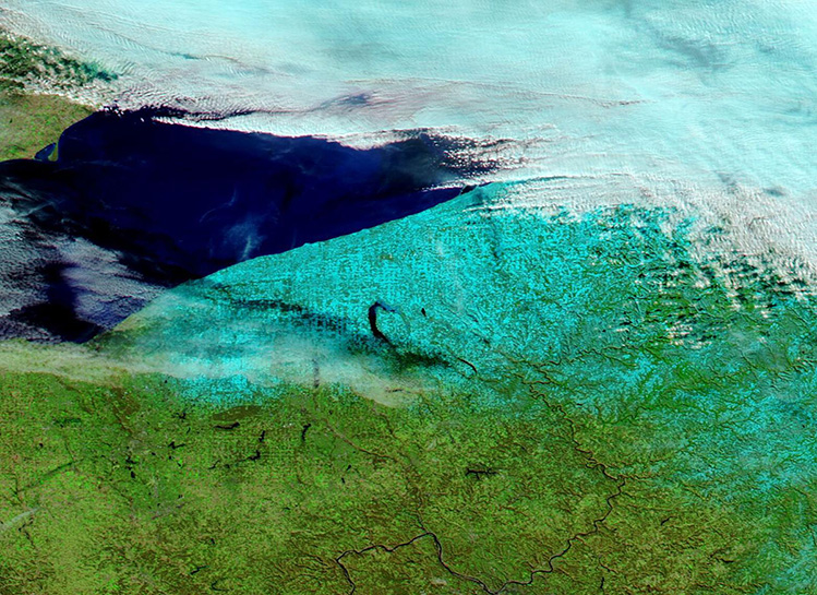
December 12, 2024 - Historic Lake Effect Snow Near Lake Erie
Tweet
Early winter blasts of frigid Canadian air repeatedly swept across Lake Erie in late November and December 2024, resulting in heavy lake effect snow. Between November 30 and December 11, more than 70 inches (178 cm) of snow had fallen in a band between Erie, Pennsylvania and Buffalo, New York, according to media reports. Drifts of 4 to 8 feet (1.2 to 2.4 meters) were also reported.
According to the National Weather Service, a “historic lake effect snow event” unfolded across the snowbelt region south and east of Lake Erie beginning Thanksgiving Day (November 28) and continued through December 3rd. The cold air interacted with above-normal Lake Erie water temperatures to produce heavy snow bands, which dropped copious snow on the eastern side of Lake Erie. Within 12 hours of the first snowflakes, a foot of snow had already been counted in some areas. Within 24 hours, Erie County, Pennsylvania, was buried under 2 ½ feet (0.76 meters) and by the afternoon of November 30, parts of northeast Ohio and northwestern Pennsylvania reported more than 3 feet (0.9 meters) of fresh snow.
After a short break, the snowfall returned on December 1 and continued through December 3 to close out the 5-day event snowfall. Totals of this first round of snow ranged from 2 to 5 feet (0.6 to 1.5 meters) across the snowbelt of Northeast Ohio and Northwest Pennsylvania. A few of the highest snowfall totals include 63.2 inches in Saybrook, Ohio, and 63.8 inches in Girard, Pennsylvania, according to the National Weather Service.
The intense snowfall from the initial 5-day event shut down roadways, causing the Pennsylvania National Guard to be deployed to assist during the storm and to rescue stranded motorists. Several reports of roof collapse were received from the areas with the heaviest snow.
Another round of lake-effect snow began to fall on December 5, adding inches to feet of new fallen snow to the totals in Pennsylvania and New York. And, as of December 11, Erie, Pennsylvania, is under yet another Lake Effect Snow Warning. Snowfall rates of up to two inches and hour are expected through the afternoon of December 12.
On December 8, the Moderate Resolution Imaging Spectroradiometer (MODIS) on NASA’s Aqua satellite acquired this false-color image of a broad band of lake effect snow spread across northwestern Pennsylvania and northwestern New York. Here, snow appears bright blue, vegetation looks green, and clouds are white, except for very cold clouds that contain ice crystals, which are tinted with bright blue. In contrast, the waters of Lake Erie—which remain ice free—look bright blue. At the time the image was captured, the band of snow which had dumped the most recent snow was moving away from the region, but still hung across the northern portion of the image.
Image Facts
Satellite:
Aqua
Date Acquired: 12/8/2024
Resolutions:
1km (103.8 KB), 500m (274.7 KB), 250m (331 KB)
Bands Used: 7,2,1
Image Credit:
MODIS Land Rapid Response Team, NASA GSFC


