Images
January 13, 2025 - California Wildfires Continue to Burn
Tweet
Months of drought that dried vegetation, warm air temperatures, low humidity and screaming Santa Ana winds set the stage for an outbreak of deadly wildfires in Los Angeles County on January 7 – 8, 2025. While many were quickly doused, three major fires continue to burn as of January 12. According to CAL FIRE, these are the Palisades Fire, the Eaton Fire, and the Hurst Fire.
The Palisades Fire, the Eaton Fire, and the Hurst Fire all ignited on January 7. The Palisades fire started in the 1100 block of North Piedra Morada Drive, near the Pacific Palisades neighborhood and by the evening on January 12 it had burned 23,713 acres and was 13 percent contained. According to CAL FIRE, more than 5,000 personnel are working the fire and damage assessment is ongoing. More than 1,000 structures have been confirmed destroyed, while aerial overlays suggest that the number may be as high as 5,000 after assessment is complete. Three civilians have been confirmed injured and at least 8 people have died, according to media reports.
The Eaton Fire was first spotted near Altadena Drive and Midwick Drive, in the Altadena/Pasadena area. As of January 12, CAL FIRE reports the size at 14,117 acres with 27 percent containment. This fire has destroyed at least 1,400 structures, injured 5 firefighters, and caused the death of at least 11 civilians, according to CAL FIRE. Media reports state that 16 civilians have died. This fire has threatened NASA’s Jet Propulsion Laboratory (JPL), which required staff to evacuate on January 8. As a result, processing of several visualization products has been temporarily suspended. Mandatory telework for JPL employees continues for the week of January 13-17, although essential personnel may have access to the site.
The Hurst Fire began near Diamond Road in Sylmar. According to CAL FIRE, it has burnt 799 acres and was 89 percent contained as of January 12. No structures have been destroyed and there have been no casualties or injuries reported. However, the entire Angeles National Forest has been closed to public access until January 15.
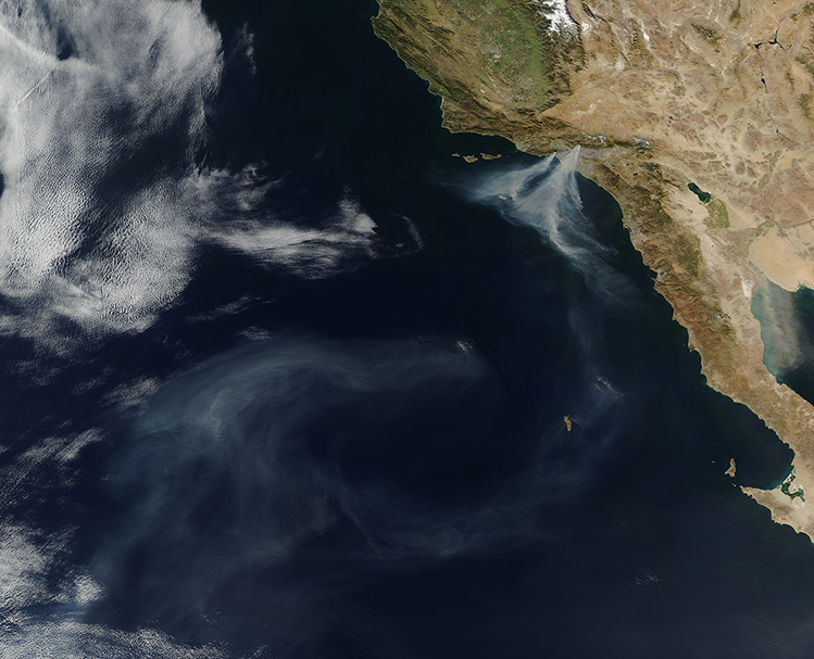
The Moderate Resolution Imaging Spectroradiometer (MODIS) on NASA’s Aqua satellite acquired a true-color image of smoke pouring from wildfires near Los Angeles. Two large plumes are visible, each carrying thick gray smoke southwest over the Pacific Ocean. Smoke from the blazes thins as it is carried nearly 870 miles (1,400 km) west of the California coast.
Image Facts
Satellite:
Aqua
Date Acquired: 1/9/2025
Resolutions:
1km (2 MB), 500m (2 MB), 250m (3 MB)
Bands Used: 1,4,3
Image Credit:
MODIS Land Rapid Response Team, NASA GSFC


