
Images


March 10, 2025 - Fires in Northeastern Argentina
 Tweet
Tweet
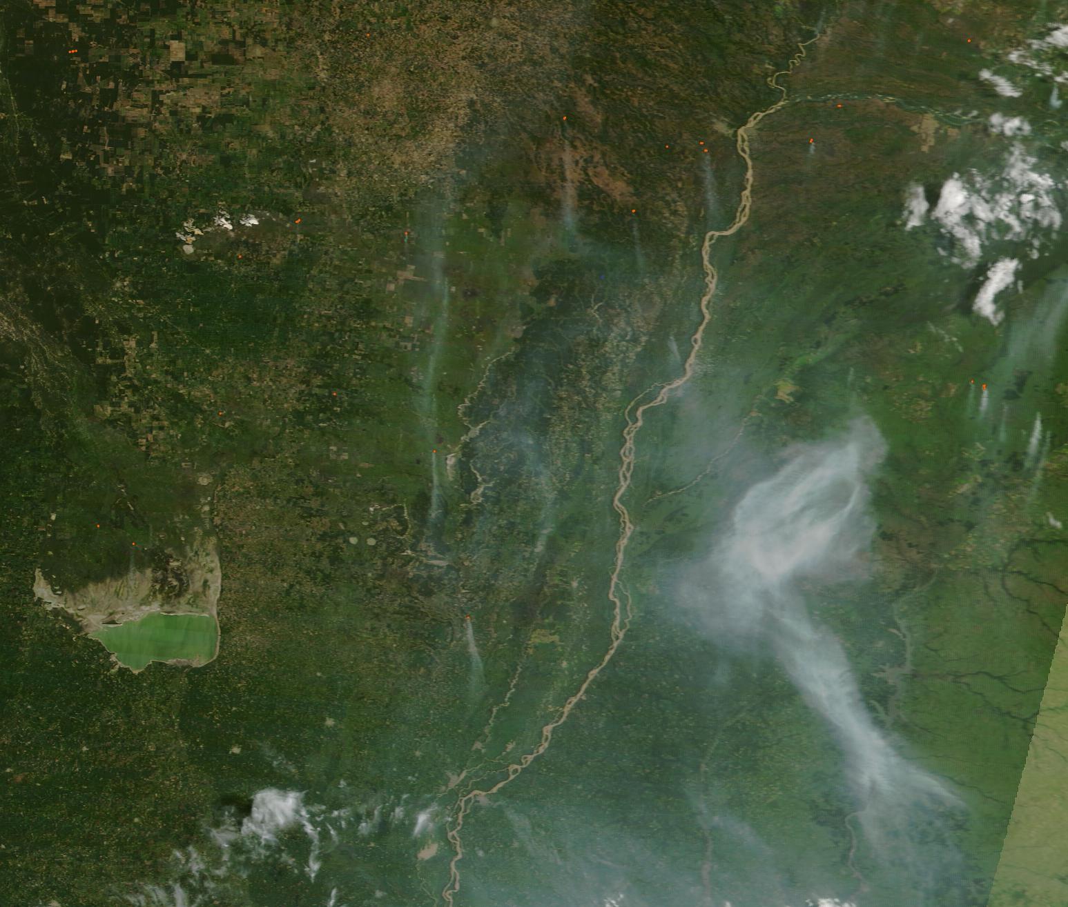
Multiple wildfires continued to burn in Argentina’s Grand Chaco and Pampas regions through early March 2025, scorching grassland and pumping smoke into the atmosphere.
The Moderate Resolution Imaging Spectroradiometer (MODIS) on NASA’s Terra satellite acquired this true-color image of the smoky scene on March 6.
In this image, the thickest cloud of smoke hangs over the provinces of Corrientes and Entre Rios, Argentina with the southeastern tail reaching Uruguay. Several thin plumes of smoke also can be seen in Corrientes, as well as in the province of Sante Fe, just west of Entre Rios and east of Mar Chiquita Lake. These locations are all in the pampas, the grassy plains of Argentina that stretch from the Andes Mountains in the west to the Atlantic Ocean in the east.
The Grand Chaco sits north of the pampas and is an arid subtropical region of savannah and dry forests. A few small red “hot spots”, each marking an area of fire activity, can be seen within the portion of Gran Chaco visible in this image, but little smoke was present.
The austral summer (December through February) is the dry season in Chile and Argentina when wildfires are more common. The fire season began early in Argentina and has been especially intense in parts of Patagonia, south of this image, with fires beginning there in December 2024. By January 2025, the northeastern prairies (Chaco and Pampas) also were ablaze. By February 12, local officials reported that nearly 250,000 hectares of land in northeast Argentina had burnt in the first six weeks of the year in northeast Argentina, with the province of Corrientes being especially hard hit.
On March 8, clouds covered the region in this image and brought much-needed rain. By March 9, when clouds cleared, the fires appeared to be significantly suppressed, with very few hot spots and little smoke visible in satellite imagery.
Image Facts
Satellite:
Terra
Date Acquired: 3/6/2025
Resolutions:
1km (73.1 KB), 500m (245.9 KB), 250m (724.2 KB)
Bands Used: 1,4,3
Image Credit:
MODIS Land Rapid Response3/5/2025 Team, NASA GSFC
Multiple wildfires continued to burn in Argentina’s Grand Chaco and Pampas regions through early March 2025, scorching grassland and pumping smoke into the atmosphere. The Moderate Resolution Imaging Spectroradiometer (MODIS) on NASA’s Terra satellite acquired this true-color image of the smoky scene on March 6.
In this image, the thickest cloud of smoke hangs over the provinces of Corrientes and Entre Rios, Argentina with the southeastern tail reaching Uruguay. Several thin plumes of smoke also can be seen in Corrientes, as well as in the province of Sante Fe, just west of Entre Rios and east of Mar Chiquita Lake. These locations are all in the pampas, the grassy plains of Argentina that stretch from the Andes Mountains in the west to the Atlantic Ocean in the east. The Grand Chaco sits north of the pampas and is an arid subtropical region of savannah and dry forests. A few small red “hot spots”, each marking an area of fire activity, can be seen within the portion of Gran Chaco visible in this image, but little smoke was present.
The austral summer (December through February) is the dry season in Chile and Argentina when wildfires are more common. The fire season began early in Argentina and has been especially intense in parts of Patagonia, south of this image, with fires beginning there in December 2024. By January 2025, the northeastern prairies (Chaco and Pampas) also were ablaze. By February 12, local officials reported that nearly 250,000 hectares of land in northeast Argentina had burnt in the first six weeks of the year in northeast Argentina, with the province of Corrientes being especially hard hit.
On March 8, clouds covered the region in this image and brought much-needed rain. By March 9, when clouds cleared, the fires appeared to be significantly suppressed, with very few hot spots and little smoke visible in satellite imagery.
Image Facts
Satellite:
Terra
Date Acquired: 3/6/2025
Resolutions:
1km (73.1 KB), 500m (245.9 KB), 250m (724.2 KB)
Bands Used: 1,4,3
Image Credit:
MODIS Land Rapid Response3/5/2025 Team, NASA GSFC
