
Images


May 13, 2025 - After the Floods, Queensland Turns Green
 Tweet
Tweet
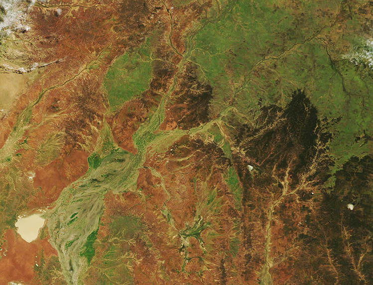
Nearly two months after extreme rains sent floodwaters flowing across the Australian interior, those typically parched areas have blossomed in swaths of green.
In late March 2025, more than a year’s worth of rain fell in one week in parts of Queensland, setting off intense and destructive flooding in Channel Country. Swollen rivers submerged towns and pasturelands while draining toward Lake Eyre (also called Kati Thanda-Lake Eyre).
As waters rose, helicopter evacuations were organized for residents of Windorah and Jundah, a town about 75 kilometers (47 miles) upriver, according to news reports. In the week ending on March 29, parts of the state of Queensland received more than 400 millimeters (16 inches) of rain. Floodwaters near Windorah, Jundah, and other towns rose to higher levels than those seen in 1974, a historic year for outback flooding and the wettest year on record in Australia.
By early May, most of the floodwater had receded but the moist ground had allowed vegetation to burst into verdant life. The Moderate Resolution Imaging Spectroradiometer (MODIS) on NASA’s Terra satellite acquired this true-color image of the reawakening of the desert in southwestern Queensland on May 10.
The channels of Cooper Creek sweep across the image, colored with a touch of remnant water and copious vegetation. The lake in the western section of the image is Lake Yamma Yamma, the largest ephemeral lake in Queensland. Most of the time it is filled with cracked soil, but severe flooding of Cooper Creek can fill Lake Yamma Yamma, as seen in this image. The town of Windorah, which suffered greatly in the floods, is located northeast of Lake Yamma Yamma, on a pointed spit of land that is now green on three sides.
Image Facts
Satellite:
Terra
Date Acquired: 5/10/2025
Resolutions:
1km (272.9 KB), 500m (752.5 KB), 250m (1.5 MB)
Bands Used: 1,4,3
Image Credit:
MODIS Land Rapid Response Team, NASA GSFC
