
Images


July 24, 2015 - Line of fires across Arnhem Land, Australia
 Tweet
Tweet
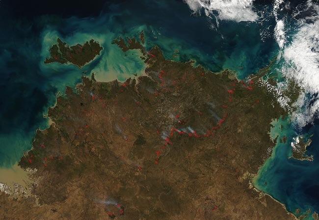
The northern tip of Australia was alight with fires early in the dry season of 2015. The Moderate Resolution Imaging Spectroradiometer (MODIS) aboard NASA’s Aqua satellite captured this true-color image on July 4.
Red hotspots are scattered across the region, including a long sinuous line of fires in the eastern section of Arnhem Land. Such hotspots mark areas where the thermal bands of the instrument detected areas of high temperature. When accompanied by smoke, as in this image, they are diagnostic for actively burning fire.
The dry season in Arnhem Land begins in May and ends in October. The days are sunny and warm, with relatively cool nights. Early in the season the vegetation is at its peak, watered by the rains of the preceding wet season. As dry days continue, however, the vegetation becomes parched and the grassy savannahs found across Arnhem Land become little more than tinder for large fires.
Arnhem Land is Aboriginal land, and culturally rich as well as biodiverse. Traditional agricultural practices involved burning small sections of savannah early in the dry season, in order to prevent large fires later in the season. This traditional had been replaced with strict fire suppression in modern times, which resulted in fewer fires, but the fires that did ignite tended to be fierce. By 1997 about 40 percent of the region burned annually, with 32 percent of the fires occurring in the late dry season. These fierce blazes destroy soil and biodiversity and emit tons of greenhouse gasses into the atmosphere each year.
Since about 1997 projects such as the West Arnhem Land Fire Abatement (WALFA) have been created to re-institute early season prescribed burns. Thus the traditional Aboriginal technique of “fighting fire with fire” is returning to this land.
Although it is not possible to determine the cause of a fire from a MODIS image, clues such as time of year, pattern, and evidence of burn scars can help make educated guesses about what is occurring on the land. Wildfires generally have a random pattern, and large wildfires can leave large burn scars.
Most of the fires scattered across the landscape are most likely wildfires. In the south, a cluster of fires cling to edges of dark burn scars. These are likely large wildfires. The long line of fires presents an unusual distribution, and an uncommon one for wildfires. Given that this is the correct time for the prescribed burns, and the pattern suggests a non-random event, it is possible that most of these fires have been set for fire-reduction purposes.
Image Facts
Satellite:
Aqua
Date Acquired: 7/4/2015
Resolutions:
1km (181.7 KB), 500m (648 KB), 250m (1.6 MB)
Bands Used: 1,4,3
Image Credit:
Jeff Schmaltz, MODIS Land Rapid Response Team, NASA GSFC
