Images
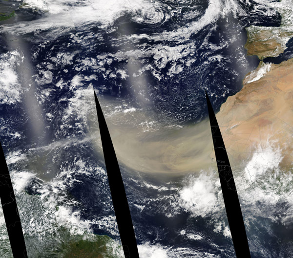
June 21, 2020 - Dust across the Atlantic
Tweet
A massive blanket of dust poured from Africa’s Sahara Desert in mid-June 2020, heading towards the Caribbean and North America. On June 18, a true-color image of the shifting sand was captured flowing more than 1,500 miles (2,500 km) across the Atlantic Ocean by the Moderate Resolution Imaging Spectroradiometer (MODIS) on board NASA’s Aqua satellite. The black strips are the areas where no data was collected between multiple passes of the satellite over the Atlantic Ocean. Three passes of Aqua were merged together to create this broad image of the moving sheet of sand.
Every year, winds loft about 800 million metric tons of desert dust from North Africa—by far the planet’s largest source of airborne dust particles. The dust is often visible from space during the spring, summer, and early fall, when huge plumes of dry, dusty air from the Sahara Desert (the Saharan Air Layer) blow westward over the tropical Atlantic Ocean.
Dust from Africa can affect air quality as far away as North and South America if it is mixed into the air near the ground. But the dust plays an important ecological role, such as fertilizing soils in the Amazon and building beaches in the Caribbean. The dry, warm, and windy conditions associated with Saharan Air Layer outbreaks can also suppress the formation and intensification of tropical cyclones.
Image Facts
Satellite:
Aqua
Date Acquired: 6/18/2020
Resolutions:
1km (7.3 MB), 500m ( B), 250m ( B)
Bands Used: 1,4,3
Image Credit:
MODIS Land Rapid Response Team, NASA GSFC


