
Images


April 1, 2024 - Mississippi River Delta
 Tweet
Tweet
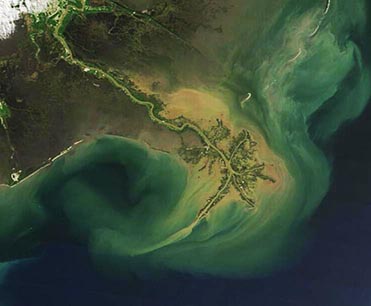
Heavy sediment poured down the lower Mississippi River and spilled into the Gulf of Mexico in late March 2024, turning the waters around the river’s vast Delta a muddy tan color. The Moderate Resolution Imaging Spectroradiometer (MODIS) on NASA’s Terra satellite acquired this true-color image of the Mississippi River Delta on March 27.
Over time, sediment carried by the Mississippi River has had a profound impact on the landforms and biodiversity of coastal Louisiana. As sediment spilled across the mouth of the Mississippi River at the Gulf of Mexico, it piled up and created new land, pushing the southern coast of Louisiana southward from 15 to 50 miles. The formation captured in this image is called the Birdsfoot Delta. It is the most southerly part of the Mississippi Delta and was created by sediment deposition over the last 5,000-7,000 years.
Image Facts
Satellite:
Terra
Date Acquired: 3/27/2024
Resolutions:
1km (47.3 KB), 500m (32.1 KB), 250m (50.8 KB)
Bands Used: 1,4,3
Image Credit:
MODIS Land Rapid Response Team, NASA GSFC
