Images
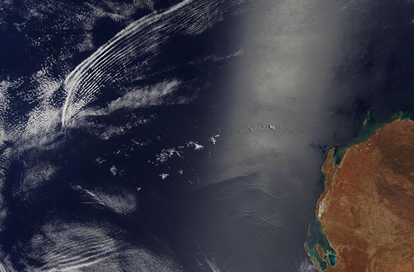
February 18, 2016 - Wave clouds and internal waves off Western Australia
Tweet
Two kinds of waves are visible in the image above, yet neither is the kind you are probably familiar with.
At 11:05 a.m. local time (03:05 UTC) on February 10, 2016, the Moderate Resolution Imaging Spectroradiometer (MODIS) aboard NASA’s Terra satellite captured this true-color image of wave patterns off the coast of Western Australia. Well offshore to the north and west, atmospheric waves are made visible by parallel bands of white clouds. Closer to the coast, the silvery area of water is sunglint – the reflection of sunlight directly back toward the satellite imager. That sunglint makes it possible to see the faint ripples of internal waves; that is, large waves that propagate below the water surface, within the depths of the sea.
Waves form in the atmosphere for a variety of reasons. Sometimes the movement of an air mass over a bumpy feature – a mountain ridge, a volcano or an island amidst a flat sea – will force air to rise or sink, creating ripples in the sky like those propagating across the surface of a pond. Other times, the collision of different air masses will cause a rippling effect.
It is unclear what caused the atmospheric waves seen in the image. Off the west coast of Africa, we often see waves form when the dry air from the Sahara moves out over the much moister air over the tropical Atlantic Ocean. The dry air tends to push the moist air higher in the atmosphere, causing water vapor to form droplets and amass in the clouds. The moist air rises, then gravity pulls it back down; the warm air rises again, then falls again. A series of cloud ripples mark the edges of the wave front as it propagates and dissipates.
Image Facts
Satellite:
Terra
Date Acquired: 2/10/2016
Resolutions:
1km (1.1 MB), 500m (3.8 MB), 250m (8.9 MB)
Bands Used: 1,4,3
Image Credit:
Jeff Schmaltz, MODIS Land Rapid Response Team, NASA GSFC


