Images
August 3, 2016 - Cliff Creek and Lava Mountain Fires, Wyoming
Tweet
Fires continued to burn across Wyoming in late July 2016 and continued into August. As of August 2, Inciweb Incident Information System reported twelve active fires across the state.
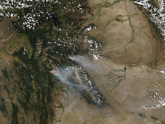
On July 27 the Moderate Resolution Imaging Spectroradiometer (MODIS) aboard NASA’s Aqua satellite captured flew over Wyoming and captured this true-color image which showed the smoke and heat from the Cliff Creek and Lava Mountain Fires.
The Lava Mountain fire is the northeasterly of the two fires. It was ignited by a lightning strike on July 11, 2016, and is burning in a mixed conifer forest with substantial bug-killed timber in the Wind River Ranger District of the Shoshone National Forest northwest of the town of Dubois, Wyoming. As of August 2, the fire was reported as 50 percent contained, with a 100 percent containment date predicted to be October 1, 2016. The fire has consumed 14,339 acres to date.
The Cliff Creek Fire began when lightning struck dry vegetation on the afternoon of July 17. As of August 2 it had burned 29,429 acres roughly 5 miles north of Bondurant, Wyoming and was reported to be 84 percent contained. Hot, dry conditions combined with strong, gusting winds continue to drive fire spotting and running, complicating fire suppression efforts.
Image Facts
Satellite:
Aqua
Date Acquired: 7/27/2016
Resolutions:
1km ( B), 500m (189.2 KB), 250m (459.3 KB)
Bands Used: 1,4,3
Image Credit:
Jeff Schmaltz, MODIS Land Rapid Response Team, NASA GSFC


