
Images


November 10, 2017 - Western Madagascar
 Tweet
Tweet
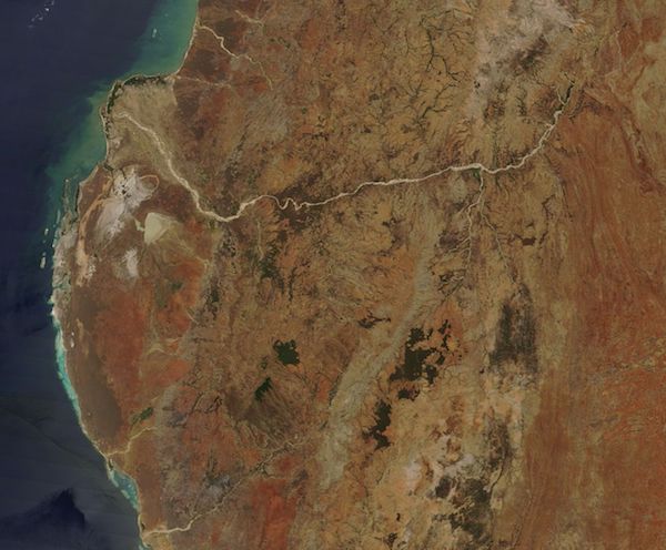
On November 1, 2017, NASA’s Terra satellite flew over western Madagascar, allowing the Moderate Resolution Imaging Spectroradiometer (MODIS) on board to acquire a true-color image of the region at the end of the dry season.
The Mangoky River winds across western Madagascar, collecting silt and mud as it flows about 350 miles (564 km) from the Central Highlands to the Mozambique Channel. The broad Mangoky River Delta fans out along the coastline just north of the small coastal city of Morombe. South of the river and well inland lies the triangle-shaped Lake Ihotry. It is a brackish lake with an area that varies with the season, at times as small as 37 square miles (96 sq. km) and as large as 43.24 sq. mi (112 sq. km). Between Lake Ihotry and the coast a large white area marks a region of sand and silt-laden ponds.
The Lake Ihotry-Mangoky River Delta region has been recognized by BirdLife International as an Important Bird Area (IBA), and became a protected area in 2015. Aside from the brackish water of the lake and the fresh-water river, the IBA contains dry deciduous forest, sub-arid spiny bushland, and savanna. The region supports 106 different species, including 23 endemic to Madagascar. In 2017, BirdLife International assessed the site, reporting the threat score of the area as “very high”, the condition score as “unfavorable”, and the action score as “high”. The highest threats come from uncontrolled burning of grassland for pasture and clearance for agriculture, as well as poaching. The slash-and-burn agricultural techniques put the wetlands and high risk of silting up. Mangrove trees are at risk from harvesting their bark for tannin and the trees for timber.
Image Facts
Satellite:
Terra
Date Acquired: 11/1/2017
Resolutions:
1km (19.6 KB), 500m (71 KB), 250m (237.9 KB)
Bands Used: 1,4,3
Image Credit:
Jeff Schmaltz, MODIS Land Rapid Response Team, NASA GSFC
