
Images


January 9, 2018 - Snow and sea ice along the eastern seaboard
 Tweet
Tweet
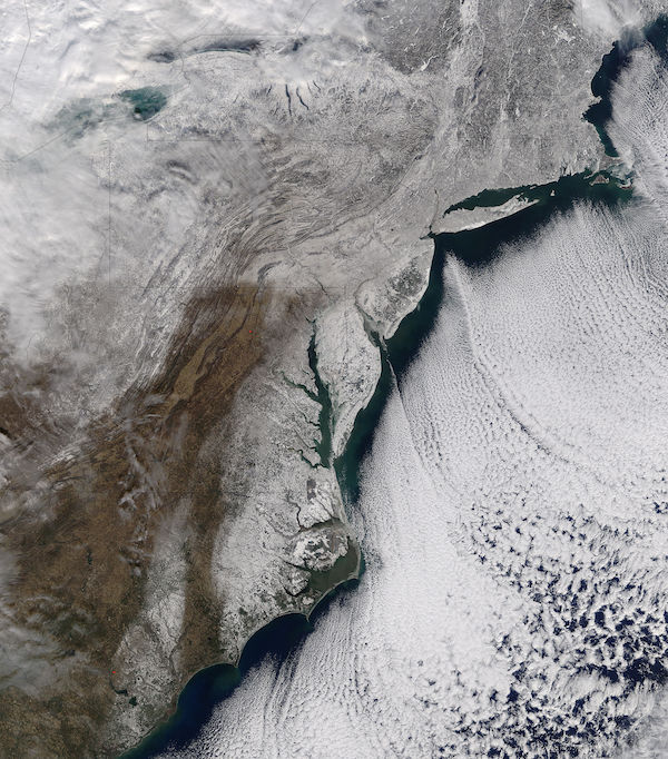
The opening week of 2018 brought intensely cold temperatures, gusty winds, power outages, travel delays, school closings, flooding, and widespread snow and ice to the East Coast of the United States. A fast-moving and rapidly-intensifying storm hit the Southeast on January 3, dropping snow on Tallahassee, Florida for the first time in thirty years. The storm strengthened as it moved northward over the Atlantic Ocean before striking the coast of South Carolina, North Carolina, Virginia, Delaware, and New Jersey on January 4, with squealing winds of up to 50 miles (80 km) per hour and dumping snow across a wide swath. Once the Nor’easter reached New England, it created white-out conditions while dumping a foot or more of snow in several locations. Drifts of three feet or more were reported on the Ocean City, Maryland boardwalk.
As the storm moved away a deep, deep chill moved in, bringing record low temperatures to several East Coast cities. According to the National Weather Service, on January 7 temperatures dropped to -20°F (-29°C) in Burlington, Vermont; -11°F in Portland, Maine; -2°F in Boston, Massachusetts; -9°F in Hartford, Connecticut; 2°F in Wilmington, Delaware; 1°F in Baltimore, Maryland; and 4°F in Raleigh, North Carolina. The long, intense period of cold brought an equally intense freeze to both inland and off-shore waters. Sea ice – which is frozen seawater that floats on the ocean surface – began to appear in amounts large enough to be seen from space from North Carolina to New England.
On January 7, 2018 the Moderate Resolution Imaging Spectroradiometer (MODIS) aboard NASA’s Terra satellite flew over the eastern United States and acquired a true-color image of snow and sea ice. White snow covers most of the region except for parts of the Appalachian Mountains. A white shimmer off the coast marks frozen seawater (sea ice) off the coast from Albemarle Sound, North Carolina to Long Island, New York. Several other MODIS images of the icy scene were published by NASA’s Earth Observatory website on January 9 and provide a closer view for interested readers. These images can be found at https://earthobservatory.nasa.gov/IOTD/view.php?id=91548&eocn=home&eoci=iotd_image .
Image Facts
Satellite:
Terra
Date Acquired: 1/7/2018
Resolutions:
1km (657 KB), 500m (2.4 MB), 250m (6.3 MB)
Bands Used: 1,4,3
Image Credit:
Jeff Schmaltz, MODIS Land Rapid Response Team, NASA GSFC
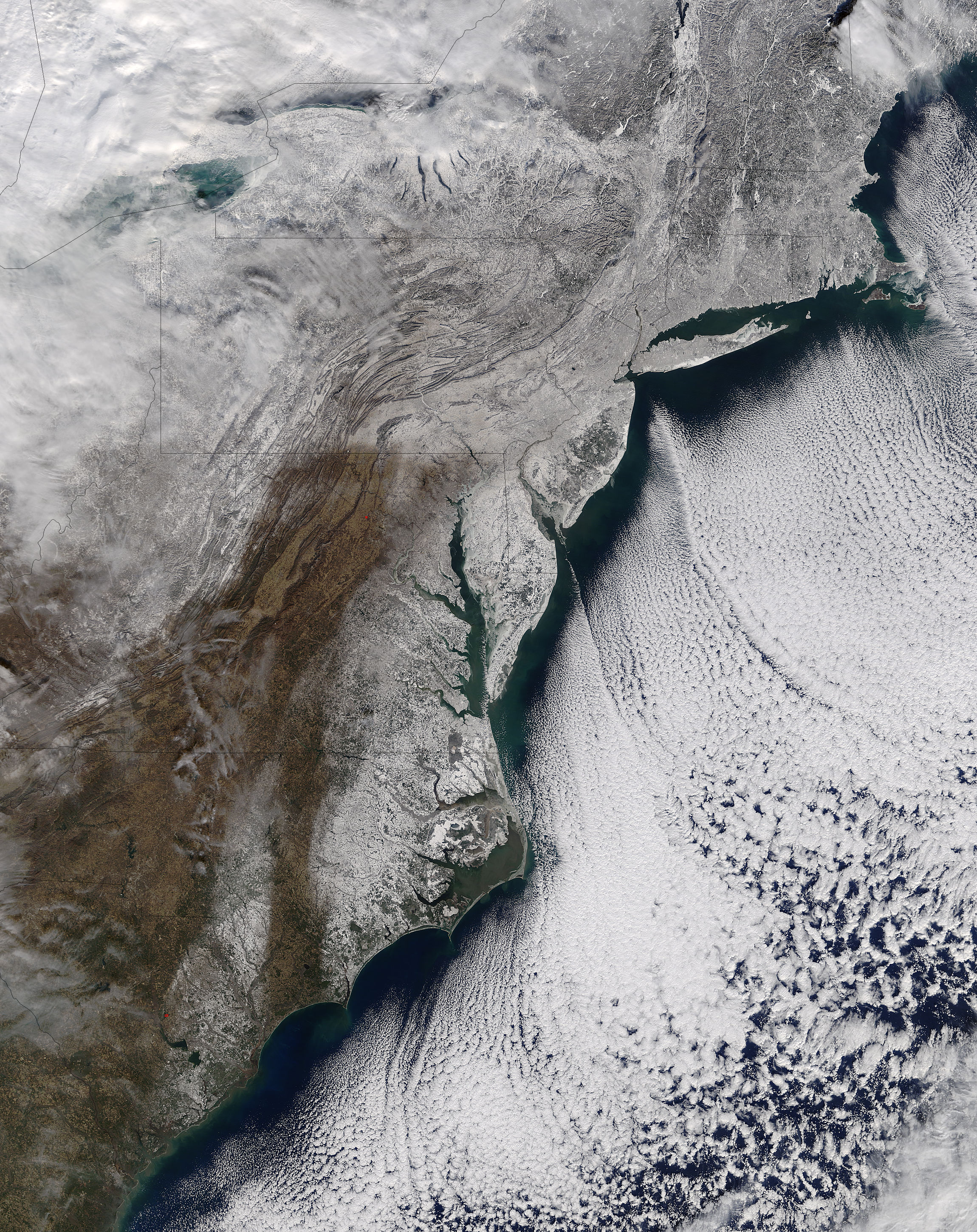
The opening week of 2018 brought intensely cold temperatures, gusty winds, power outages, travel delays, school closings, flooding, and widespread snow and ice to the East Coast of the United States. A fast-moving and rapidly-intensifying storm hit the Southeast on January 3, dropping snow on Tallahassee, Florida for the first time in thirty years. The storm strengthened as it moved northward over the Atlantic Ocean before striking the coast of South Carolina, North Carolina, Virginia, Delaware, and New Jersey on January 4, with squealing winds of up to 50 miles (80 km) per hour and dumping snow across a wide swath. Once the Nor’easter reached New England, it created white-out conditions while dumping a foot or more of snow in several locations. Drifts of three feet or more were reported on the Ocean City, Maryland boardwalk.
As the storm moved away a deep, deep chill moved in, bringing record low temperatures to several East Coast cities. According to the National Weather Service, on January 7 temperatures dropped to -20°F (-29°C) in Burlington, Vermont; -11°F in Portland, Maine; -2°F in Boston, Massachusetts; -9°F in Hartford, Connecticut; 2°F in Wilmington, Delaware; 1°F in Baltimore, Maryland; and 4°F in Raleigh, North Carolina. The long, intense period of cold brought an equally intense freeze to both inland and off-shore waters. Sea ice – which is frozen seawater that floats on the ocean surface – began to appear in amounts large enough to be seen from space from North Carolina to New England.
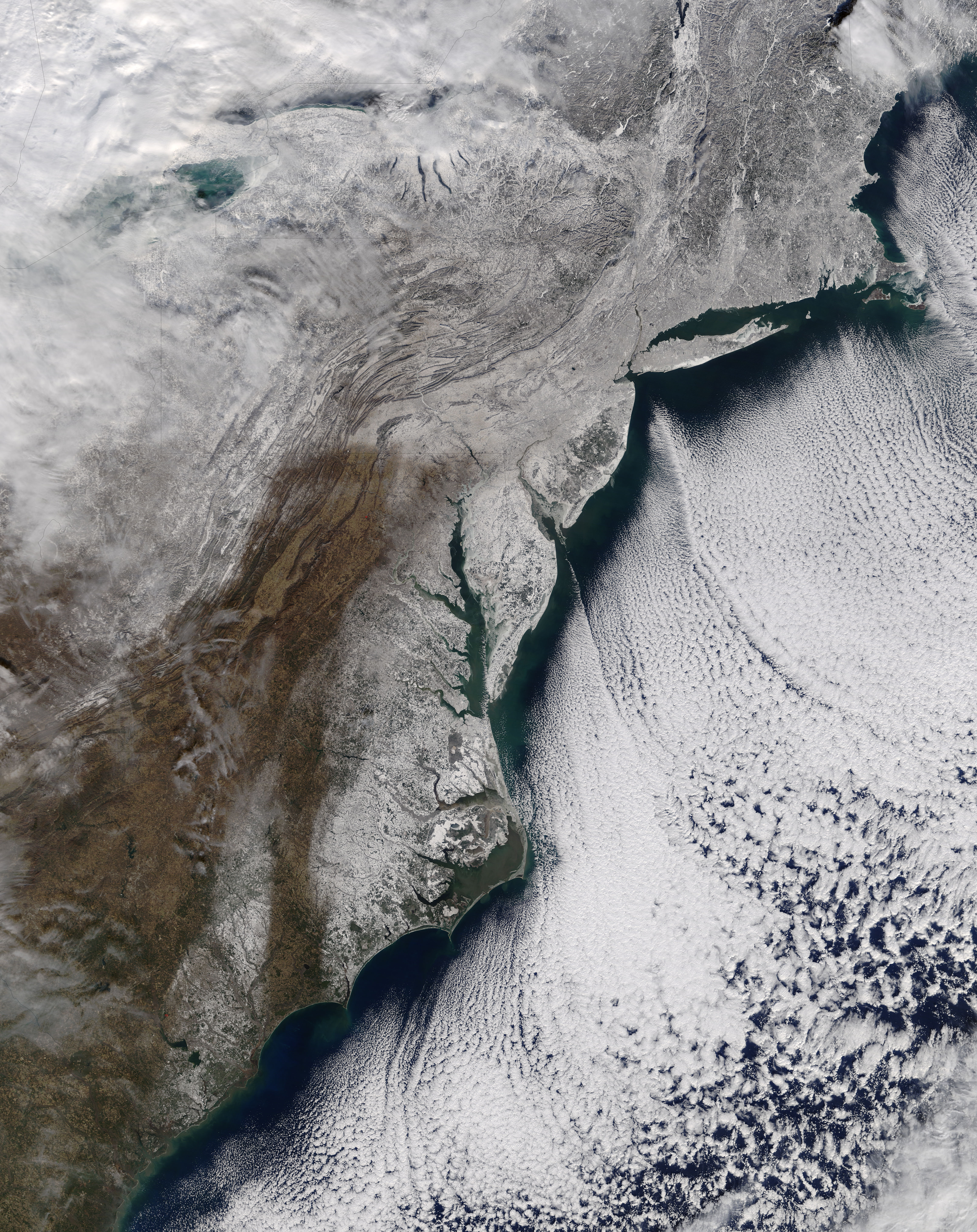
On January 7, 2018 the Moderate Resolution Imaging Spectroradiometer (MODIS) aboard NASA’s Terra satellite flew over the eastern United States and acquired a true-color image of snow and sea ice. White snow covers most of the region except for parts of the Appalachian Mountains. A white shimmer off the coast marks frozen seawater (sea ice) off the coast from Albemarle Sound, North Carolina to Long Island, New York. Several other MODIS images of the icy scene were published by NASA’s Earth Observatory website on January 9 and provide a closer view for interested readers. These images can be found at https://earthobservatory.nasa.gov/IOTD/view.php?id=91548&eocn=home&eoci=iotd_image .
Image Facts
Satellite:
Terra
Date Acquired: 1/7/2018
Resolutions:
1km (657 KB), 500m (2.4 MB), 250m (6.3 MB)
Bands Used: 1,4,3
Image Credit:
Jeff Schmaltz, MODIS Land Rapid Response Team, NASA GSFC
