
Images


February 17, 2018 - Ice on the Great Lakes (true color)
 Tweet
Tweet
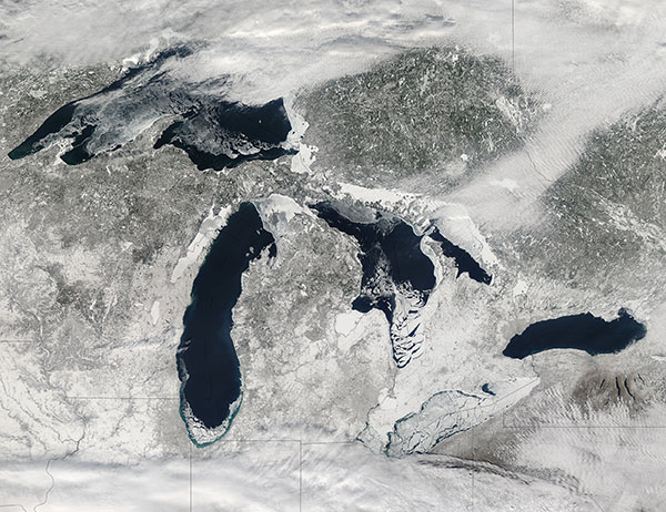
An unusually frigid winter across the Upper Midwest brought a hard freeze to waters of the Great Lakes. The Moderate Resolution Imaging Spectroradiometer (MODIS) aboard NASA’s Aqua satellite acquired a true-color image of the wintery scene on February 14.
On the day the image was acquired, 57.9 percent of the Great Lakes was covered with ice, according to NOAA’s Great Lakes Environmental Research Laboratory. On the same date last year, total ice cover was 9.7 percent. Lake Erie was the iciest of the five lakes, with 93.3 percent of it iced over.
Lake Erie is slightly larger than Lake Ontario (the smallest of the five Great Lakes) in terms of surface area. But Erie is relatively shallow and contains less than one-third of the volume of water found in Lake Ontario, so it is generally the first to freeze in winter and the first to thaw in spring.
Image Facts
Satellite:
Aqua
Date Acquired: 2/14/2018
Resolutions:
1km (451.7 KB), 500m (1.7 MB), 250m (4.3 MB)
Bands Used: 1,4,3
Image Credit:
Jeff Schmaltz, MODIS Land Rapid Response Team, NASA GSFC
