Images
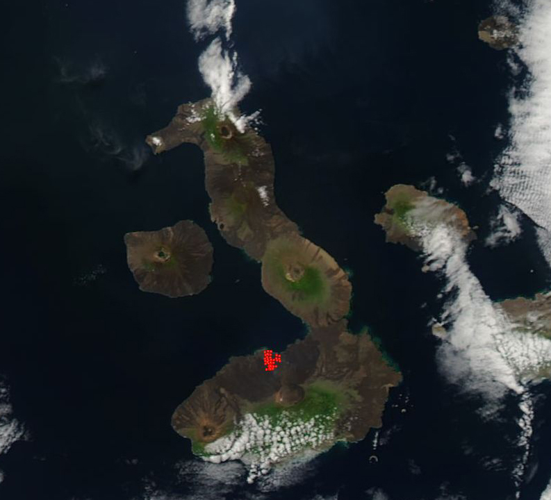
August 4, 2018 - Sierra Negra volcano, Galapagos Island
Tweet
In mid-June, 2018, intense seismic activity under the Sierra Negra Volcano on Isla Isabela in the Galapagos Islands signaled an imminent eruption. On June 26, the eruption began dramatically with strong fountaining and multiple lava flows – the first eruption since 2005.
According to the Global Volcanism Program report of 25-31 July, the eruption at Sierra Negra continued, with nightly incandescence from advancing lava flows. Sulfur dioxide flux was as high as about 1,400 tons per day on July 28, and gas plumes drifted north, northwest, and west.
The Moderate Resolution Imaging Spectroradiometer (MODIS) on board NASA’s Aqua satellite acquired a true-color image of Isla Isabella on August 2. The large red hot-spot marks areas where the thermal bands on the instrument detected temperatures higher than background. In this case, they mark volcanic activity – most likely a field of hot lava which has flowed from the volcano.
The Galapagos Islands are a collection of volcanic summits poking their heads above sea level along the equator, west of South America. With the exception of Isla Isabela, each major island consists of a single volcanic summit. Isla Isabela, the largest in the archipelago, is composed of six volcanoes that merged above the water, including Wolf Volcano, Darwin Volcano, Alcedo Volcano, and Sierra Negra Volcano. These volcanoes are all shield volcanoes shaped like flattened domes with very gentle slopes. In contrast to volcanoes built from a combination of lava, rock, and ash flows, shield volcanoes are built exclusively from lava flows. Hardened black lava characterizes the islands, and the Sierra Negra’s name translates as “Black Mountain Range.”
Image Facts
Satellite:
Aqua
Date Acquired: 8/2/2018
Resolutions:
1km (121.7 KB), 500m (296.5 KB), 250m (225.1 KB)
Bands Used: 1,4,3
Image Credit:
MODIS Land Rapid Response Team, NASA GSFC


