
Images


September 19, 2018 - Burn Scars and Fires in California
 Tweet
Tweet
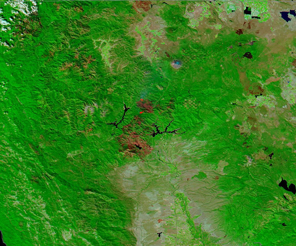
On September 16, 2018, the Moderate Resolution Imaging Spectroradiometer (MODIS) aboard NASA’s Aqua satellite flew over northern California and acquired a false-color image of fire scars near Redding, California.
The 2018 fire season has been hard on California, putting some of the largest fires in the history of the state into the record books. The forests near Redding, California have been especially hard hit, starting with the hugely damaging Carr Fire, which began on July 23 and burned 229,651 acres before containment in early September. The Carr Fire destroyed 1,079 homes, 22 commercial structures, and 503 outbuildings, with many more damaged in and near the town of Redding.
After that fire was quelled, other fires ignited in the dry forests, driven by high temperatures, low humidity, and gusting winds. Two of the largest were the Hirz Fire, which started on August 9 from human activity in woods and fields 18 miles northeast of Redding. It burned 46,500 acres before being 100 percent contained on September 12. The Delta Fire ignited on September 5 due human activity about 2 miles north of Lakehead, California. As of September 18, the Delta Fire had consumed 60,277 acres of timber, brush, mixed conifer of varying ages with heavy dead and down surface fuels and destroyed 17 structures. More than 2,300 personnel were working the fire, which had reached 81 percent containment. The Delta Fire burned into the Hirz Fire by September 8 and was very close to the scar of the Carr Fire.
False-color images are helpful to show the extent of destruction of fires. The images are created from a combination of visible and infrared light using data from MODIS bands 7, 2, and 1. With this combination, burned areas appear brick red and vegetation bright green, creating a clear contrast at the fire line. Desert or semi-arid landscapes are beige, dense urban areas (cities) are gray, and water appears dark blue. Actively burning areas (hot spots) appear red or orange. As vegetation grows into old burn scars, the area becomes greener with a brick-red base.
The large burn scar of the Carr Fire can be seen between Shasta Lake (east) and Trinity Lake (west), and encircling Whiskeytown Lake. The burn scar of the Delta Fire is just north of the Carr Fire and appears roughly round. Just to the east the burn scar of the smaller Hirz Fire appears lighter brick red. Two red hot spots sit at the edge of the still-active Delta Fire, one in the north and one on the southwest edge, which appears to be burning into the scar of the Carr Fire.
Image Facts
Satellite:
Aqua
Date Acquired: 9/16/2018
Resolutions:
1km (155.5 KB), 500m (401.9 KB), 250m (268.4 KB)
Bands Used: 7,2,1
Image Credit:
MODIS Land Rapid Response Team, NASA GSFC
