
Images


October 28, 2018 - Tibetan Plateau, Himalaya Mountains, and Indo-Gangetic Plain
 Tweet
Tweet
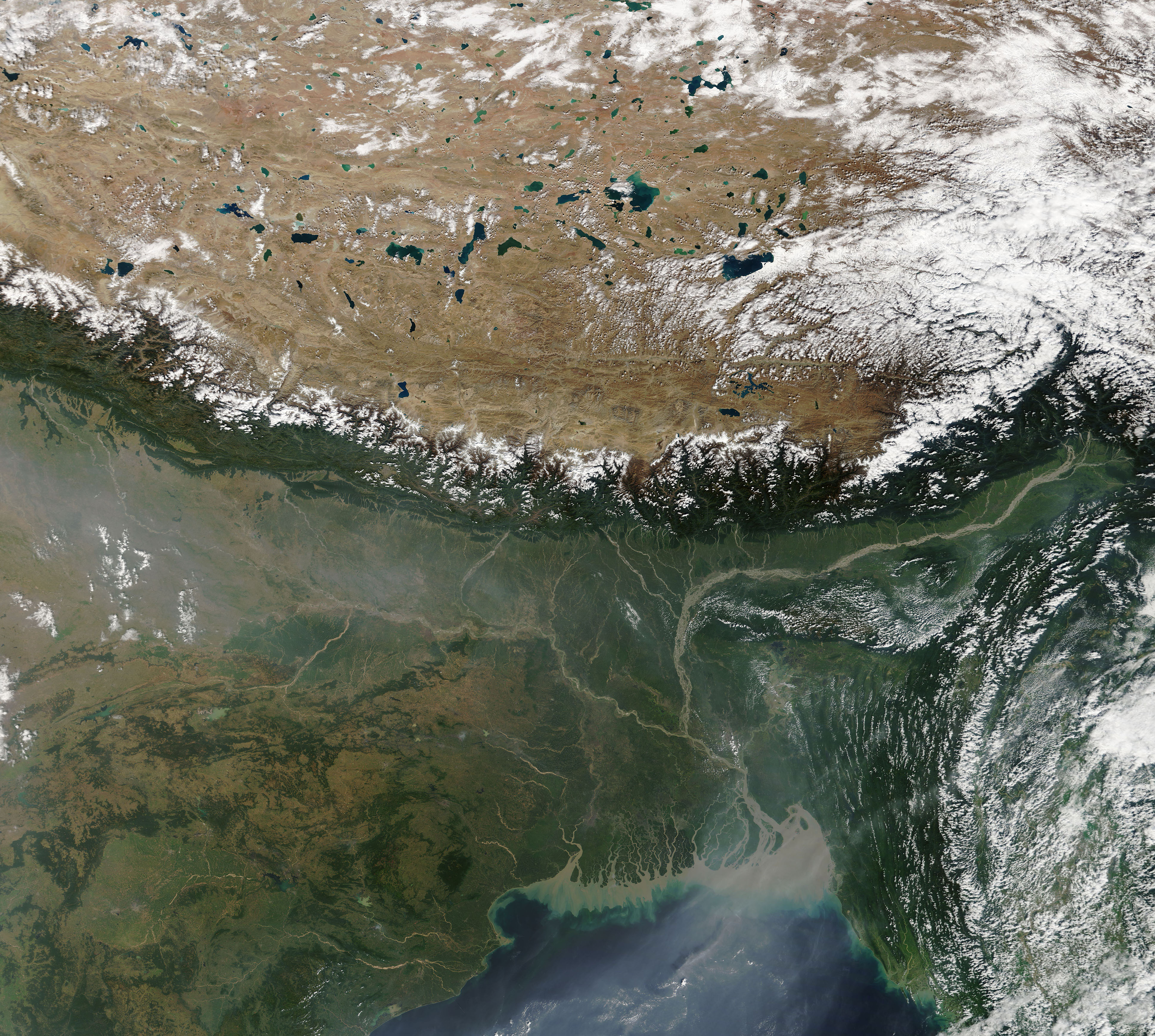
On October 25, 2018, the Moderate Resolution Imaging Spectroradiometer (MODIS) on board NASA’s Terra satellite passed over Central Asia and acquired a stunning true-color image of some of the world’s most distinctive topography—the place where the “roof of the world” meets the world’s tallest mountains then drops to the lowlands one of the Earth’s most fertile agricultural regions.
The geological story of the region is one that began some 40 million years ago, when the Indian tectonic plate began a slow-moving collision with the Eurasian plate. As India smashed into Eurasia, the crust along the line of impact buckled, building up soaring mountain ranges.
Only fourteen mountain peaks on Earth stand taller than 8,000 meters (26,247 feet) – all found within the Himalaya mountain system (including Himalaya and Karakoram ranges). The 8K mountains found within this image include Dhaulagiri, Annapurna, Manaslu, Shisha Pangma, Cho Oyu, Mount Everest, Lhotse, Makalu, and Khanchenjunga.
North of the Himalayas, the Tibetan Plateau, the high-altitude region sometimes called the “Roof of the World”. With an average elevation of more than 4,500 meters (14,700 feet), the Tibetan Plateau is home to more than 1,500 large and small lakes that cover 24,183 square kilometers (9,337 square miles). The area is also the source of many of Asia’s major rivers, including the Brahmaputra, Indus, Ganges, Salween (Nu Jiang), Mekong (Lancang Jiang), Yangtze (Chang Jiang), and Yellow (Huang He) Rivers.
South of the Himalayas the Indo-Gangetic Plain, a large, low-lying alluvial crescent that stretches from the Indus River system in Pakistan to the Punjab Plain of India to the delta of the Ganges River in Bangladesh. The fertile soils sustain a rich agricultural region which is irrigated by major river systems, including the Brahmaputra (east) and the Ganges (in the west). Parts of this region, particularly south of the towering Himalayas, are often covered by haze, which is often the result of smoke from agricultural fires in northern India and Pakistan, smog from the heavily-populated cities, industry, and automobiles, as well as frequent inversions which act to hold a layer of hazy air close to the ground—sometimes for days.
The countries seen in this image include, from north to south: the Tibetan Autonomous Region of China, seated on the Tibetan Plateau; Nepal, Bhutan and the Arunachal Pradesh region of India perch in the high Himalayas; and, from west to east south of the mountains sit India, Bangladesh, and, to the east of the Bay of Bengal, Myanmar (Burma).
Image Facts
Satellite:
Terra
Date Acquired: 10/25/2018
Resolutions:
1km (1 MB), 500m (3.2 MB), 250m (8.3 MB)
Bands Used: 1,4,3
Image Credit:
MODIS Land Rapid Response Team, NASA GSFC
