
Images


March 29, 2019 - Sediment in the Bohai Sea, Yellow Sea, and East China Sea
 Tweet
Tweet
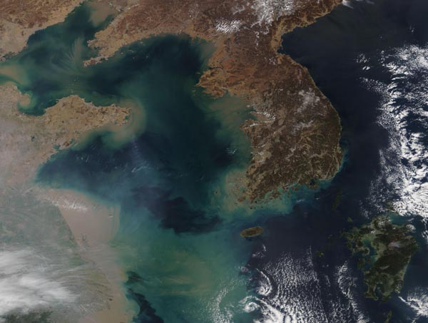
On March 23, 2019, the Moderate Resolution Imaging Spectroradiometer (MODIS) on board NASA’s Aqua satellite acquired a true-color image of the Korean Peninsula and eastern China—and of the turbid, sediment-filled waters of the Bohai Sea, Yellow Sea, and East China Sea.
A number of factors cause the heavy sediment common in these waters: strong currents lift sediment from shallow ledges and bottoms; rivers dump loads of sediment carried from the interior into the seas; rains may wash sediment from the land into the oceans; and strong tidal motion may swirl sediment along the coastlines. Plant-like organisms (phytoplankton) may also be color the water in shades of blue or green as they reproduce and float in the water.
The most massive tan area sits near the coast of China in the southwestern section of the image. This is China’s Subei Shoal and shallow water depths, tidal currents, and the strong winds typical at the end of winter likely contribute to the dramatic mixing of sediment through the water.
In the north, the Huang He (Yellow River) flows into the Bohai Sea. One of the most sediment-filled rivers on Earth, the Yellow River flows northeast from the Bayan Har Mountains, crossing a plateau blanketed with up to 300 meters (980 feet) of fine, wind-blown soil. The soil is easily eroded, and millions of tons of it are carried away each year, some of it reaching the river’s mouth. At the mouth, some sediment is deposited to build the broad delta while the rest flows into the Bohai Sea.
Some of the swirling sediment may also be caused by the Yellow Sea Warm Current, which intrudes into the Yellow Sea in winter and fades later in the year. A branch of the Kuroshio Current, the intrusion changes the temperature of the sea surface and brings instability to the waters.
Image Facts
Satellite:
Aqua
Date Acquired: 3/24/2019
Resolutions:
1km (239.4 KB), 500m (767.1 KB), 250m (2.5 MB)
Bands Used: 1,4,3
Image Credit:
MODIS Land Rapid Response Team, NASA GSFC
