
Images


July 3, 2019 - Ice in Kane Basin
 Tweet
Tweet
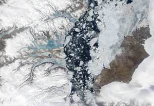
Ice break-up was well underway in late June 2019, when NASA’s Terra satellite passed overhead. The Moderate Resolution Imaging Spectroradiometer (MODIS) on board acquired true-color image on June 27.
The Kane Basin is a waterway in the Arctic lying between Ellesmere Island (Canada’s northernmost island) and Greenland. About 82 miles (130 km) at the widest point and about 112 mi (180 km) long, the Kane Basin links Smith Sound to Kennedy Channel, forming a part of the Nares Strait. Ice melt in this region occurs each summer and refreezes each winter. With a strong heat wave over much of the Arctic Ocean this winter, ice breakup has come early in both the Nares Strait and the Kane Basin.
Image Facts
Satellite:
Terra
Date Acquired: 6/27/2019
Resolutions:
1km (87 KB), 500m (252.2 KB), 250m (775.3 KB)
Bands Used: 1,4,3
Image Credit:
MODIS Land Rapid Response Team, NASA GSFC
