
Images


October 31, 2019 - Pacific Northwest
 Tweet
Tweet
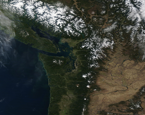
On October 27, 2019, the Moderate Resolution Imaging Spectroradiometer (MODIS) on board NASA’s Terra satellite acquired a true-color image of an autumn day in the Pacific Northwest.
In the south, small amounts of snow sits on the higher peaks of the Cascade Range, which runs roughly parallel to the Pacific Coast of the United States. In contrast, Canada’s Coast Mountains wear a substantial snowpack as well as the Rocky Mountains, inland. The large, green island sitting off the coast of mainland Canada is Vancouver, Canada. Several active volcanoes—Mount St. Helens, Mount Rainier and Mount Hood—dot the Cascades. One of the space station’s solar arrays points into the view on the upper left.
Greener, forested landscapes are evidence of the wet climate experienced by people who live near the coast and on the seaward slopes of the mountains. By contrast, the tan colors of the dry Columbia Basin (lower right part of the image) show the rain shadow effect of the Cascades in preventing rain-bearing air masses from reaching the basin. The Columbia River drains the basin, cutting directly through the Cascades at Columbia River Gorge, and then flows into the Pacific Ocean.
Image Facts
Satellite:
Terra
Date Acquired: 10/27/2019
Resolutions:
1km (795.1 KB), 500m (2.1 MB), 250m (4.2 MB)
Bands Used: 1,4,3
Image Credit:
MODIS Land Rapid Response Team, NASA GSFC
