Images
December 6, 2019 - Arc of Cold Cloud
Tweet
Chances are good that you have heard of the jet stream, a river of fast-moving air in the upper levels of the atmosphere. World War II pilots were among the first to notice jet stream winds, which play a key role in steering air masses and storms around the globe.
Jet streaks—pockets of extremely fast winds embedded within the jet stream—are mentioned less often. Yet they are important to the formation of winter storms because they are associated with rising air, which can trigger clouds and precipitation.
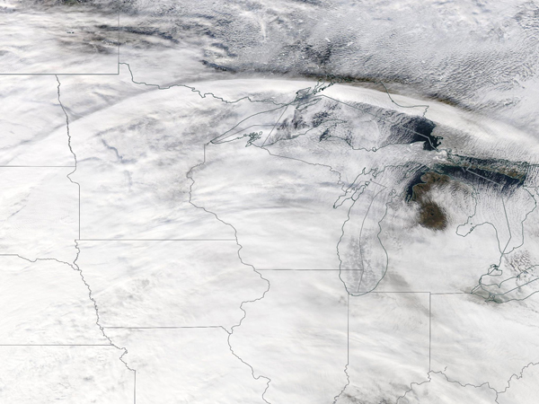
The presence of a jet streak is not often apparent in natural-color satellite imagery, but occasionally there are tell-tale signs. That was the case on November 28, 2019, when the Moderate Resolution Imaging Spectroradiometer (MODIS) on NASA’s Aqua satellite captured this true-color image of a wide arc of clouds stretching across the northern United States. At the time, a powerful winter storm was building in the East.
“The arc is a cirrus cloud associated with the jet streak. There was just enough moisture and upward motion to create localized cirrus clouds on the poleward side of the jet stream,” explained Emily Berndt, a Short-term Prediction Research and Transition Center (SPoRT) scientist at NASA’s Marshall Space Flight Center.
When the image was acquired, air was circulating around the entrance of the jet streak near Nebraska. As air enters a jet streak, it generally speeds up. In this case, warmer air was rising to the south of the cloud band, and cooler air was sinking north of it.
Rising air tends to produce clouds: air cools as it rises, and cooler air can hold less moisture. This causes water vapor to condense into droplets or ice particles. Once the cirrus clouds formed, strong winds associated with the jet streak carried them downstream, pulling them north and east.
The winter storm associated with this jet streak proved to be a significant one, blowing across the Midwest and New England and dropping more than 1 foot (0.3 meters) of snow in some areas.
Image Facts
Satellite:
Aqua
Date Acquired: 12/28/2019
Resolutions:
1km (414.7 KB), 500m (1.5 MB), 250m (4.7 MB)
Bands Used: 1,4,3
Image Credit:
MODIS Land Rapid Response Team, NASA GSFC
Tweet
Chances are good that you have heard of the jet stream, a river of fast-moving air in the upper levels of the atmosphere. World War II pilots were among the first to notice jet stream winds, which play a key role in steering air masses and storms around the globe.
Jet streaks—pockets of extremely fast winds embedded within the jet stream—are mentioned less often. Yet they are important to the formation of winter storms because they are associated with rising air, which can trigger clouds and precipitation.
The presence of a jet streak is not often apparent in natural-color satellite imagery, but occasionally there are tell-tale signs. That was the case on November 28, 2019, when the Moderate Resolution Imaging Spectroradiometer (MODIS) on NASA’s Aqua satellite captured this true-color image of a wide arc of clouds stretching across the northern United States. At the time, a powerful winter storm was building in the East.
“The arc is a cirrus cloud associated with the jet streak. There was just enough moisture and upward motion to create localized cirrus clouds on the poleward side of the jet stream,” explained Emily Berndt, a Short-term Prediction Research and Transition Center (SPoRT) scientist at NASA’s Marshall Space Flight Center.
When the image was acquired, air was circulating around the entrance of the jet streak near Nebraska. As air enters a jet streak, it generally speeds up. In this case, warmer air was rising to the south of the cloud band, and cooler air was sinking north of it. Rising air tends to produce clouds: air cools as it rises, and cooler air can hold less moisture. This causes water vapor to condense into droplets or ice particles. Once the cirrus clouds formed, strong winds associated with the jet streak carried them downstream, pulling them north and east.
The winter storm associated with this jet streak proved to be a significant one, blowing across the Midwest and New England and dropping more than 1 foot (0.3 meters) of snow in some areas.
Image Facts
Satellite:
Aqua
Date Acquired: 12/28/2019
Resolutions:
1km (414.7 KB), 500m (1.5 MB), 250m (4.7 MB)
Bands Used: 1,4,3
Image Credit:
MODIS Land Rapid Response Team, NASA GSFC


