
Images


February 2, 2020 - Sea Ice in the Sea of Okhotsk
 Tweet
Tweet
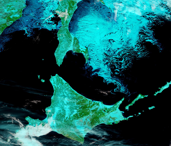
Each winter, frigid winds from East Siberia blow over the Sea of Okhotsk, helping drive down sea surface temperatures and setting the stage for formation of copious sea ice. The inflow of fresh water from several rivers, including the Amur River, also aids in sea ice formation, as less-saline water freezes at higher temperatures that saline water. These features, along with typical bitterly cold winter temperatures, help make the Sea of Okhotsk the lowest latitude for seasonal sea ice formation in the world.
On January 28, 2020, the Moderate Resolution Imaging Spectroradiometer (MODIS) on board NASA’s Terra satellite acquired a stunning false-color image of sea ice floating on the Sea of Okhotsk.
True-color images use red, green, and blue light to create an image that looks very much like we could see if we looked with our own vision. False-color images add infrared light to the mix. Infrared is invisible to our eyes, but not to satellites. By assigning a mix of red, green, and blue to visible and infrared light, scientists can see some things more clearly than true-color—such as sea ice.
In this particular type of false-color image, using bands 7, 2 and 1, areas with plants look bright green while open land appears tan. Cold things appear blue, and the colder something is, the brighter blue it will appear. Ice and snow on the ground show up as bright turquoise, while clouds may range from white, to baby-blue, to bright turquoise. Deep water appears black.
In this image, a thin layer of snow (bright blue) overlies the Eastern Russian mainland, Russia’s Sakhalin Island, and Hokkaido Island, Japan. Bright green, indicating vegetation, can be seen around and through the snow. On the dark waters of the Sea of Okhotsk, electric blue marks thick, cold, sea ice. A few white clouds float above the scene. At the margins of the sea ice near the shore, the ice is thinner and likely contains more water as well, which is why it appears darker in color than the off-shore ice.
Image Facts
Satellite:
Terra
Date Acquired: 1/28/2020
Resolutions:
1km (799.2 KB), 500m (2 MB), 250m (1.4 MB)
Bands Used: 7,2,1
Image Credit:
MODIS Land Rapid Response Team, NASA GSFC
