
Images


June 22, 2020 - Fire and Ice in Russia
 Tweet
Tweet
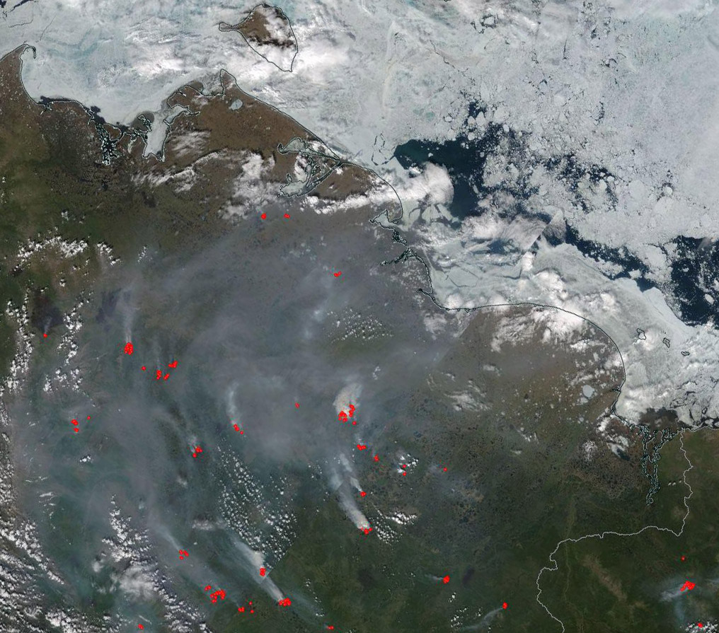
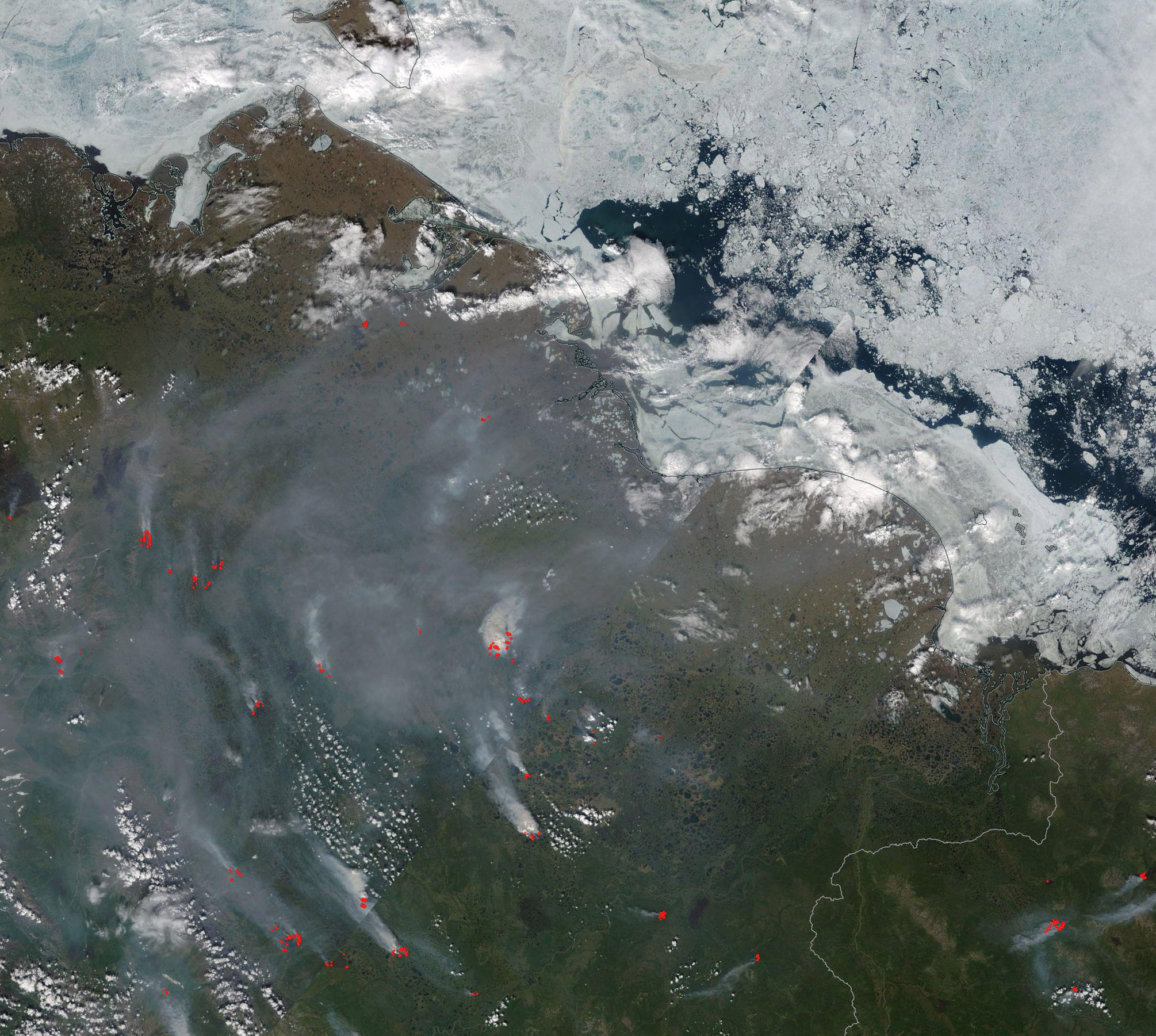
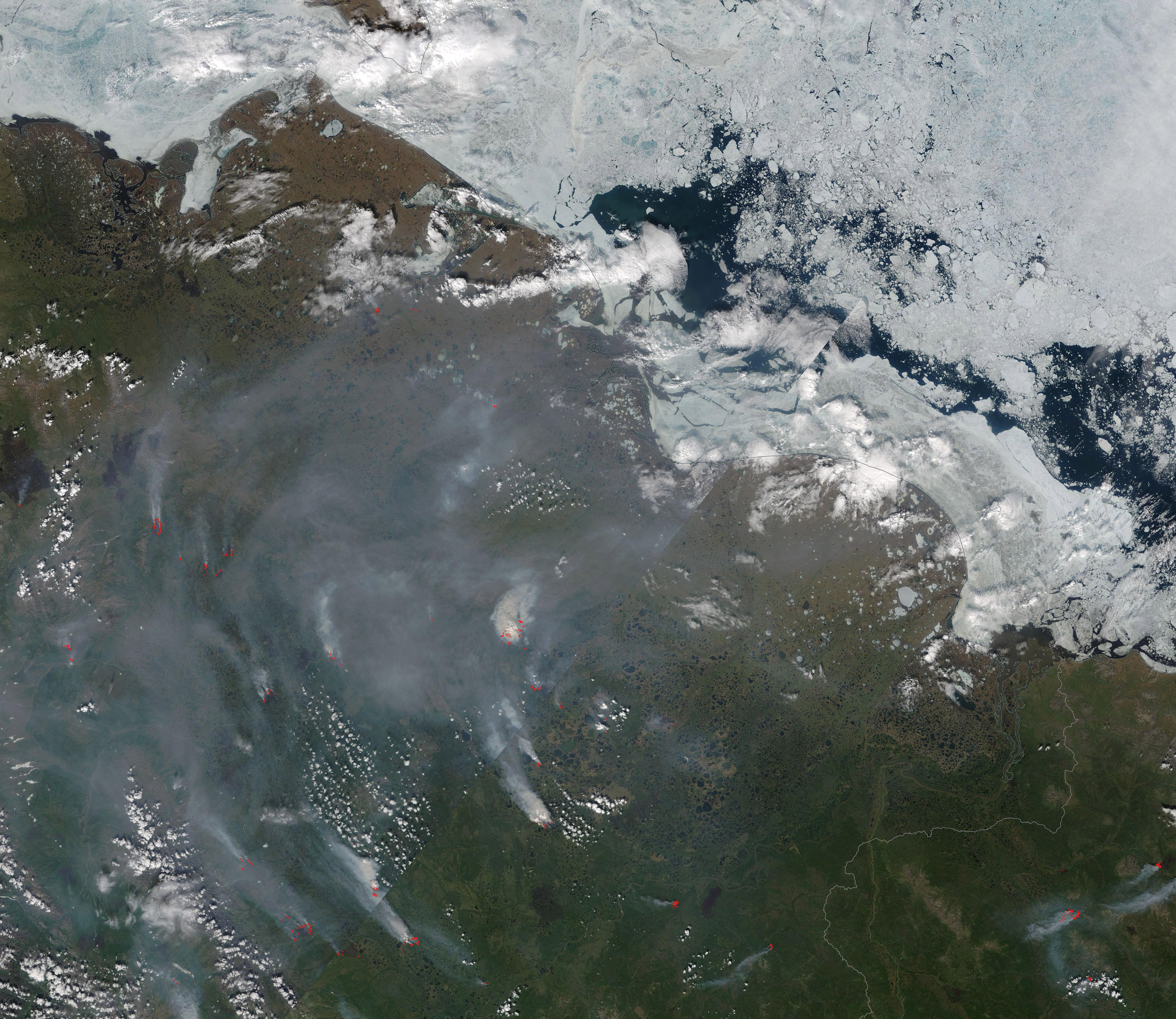
The 2020 Siberian fire season roared to life early following an exceptionally warm, dry winter. On June 19 the Moderate Resolution Imaging Spectroradiometer (MODIS) on board NASA’s Terra satellite acquired a true-color image showing the stark contrast of tundra ablaze while winter’s sea ice still coats the East Siberian Sea.
Each red hot spots marks an area where the thermal bands on the instrument detected high temperatures. Combined with typical smoke, as in this image, such hot spots are diagnostic for actively burning fire. The extremely heavy smoke and location strongly suggests that most of these fires are burning in peat, which typically remains frozen at this time of year in this location. When viewed at high resolution, it is even more clear that most of the fires are located not in forests (taiga) but the sparsely vegetated tundra—and most are close to very wet areas which appear to be thermokarst. Thermokarst is a land surface characterized by irregular surfaces of marshy hollows and small hummocks formed as ice-rich permafrost thaws.
These fires are located in the Sakha Republic of northern Siberia. Most are well above the Arctic Circle. Only in a few areas towards the south do the fires appear to burn in dark green areas typical of heavy vegetation or forest. Many of these fires also burn very close to areas that were on fire in August, before temperatures dropped and some snow began to fall. Some scientists believe that some of the fires seen in this image have actually overwintered underground, smoldering in the thawing peat, until warming temperatures allowed them to spring to blazing life early this spring. Fires were seen in this region as early as April this year, which is an exceptionally early start to fire season.
Peat fires are notorious for their potential to over-winter smoldering underground only to reappear in early spring. The term for reappearing fires that are renewed in spring is “zombie fires”.
Western and Central Siberia have experienced extreme warmth recently. Not only was 2019 the warmest on record in Russia, but estimates of the January – April 2020 heatwave puts the temperature anomaly at 5.3-6°C (41.5 – 42.8°F) above normal. This is the greatest average temperature anomaly ever recorded by any country.
But that heatwave has not cooled down. On May 22, 2020 the town of Khatanga, located in Krasnoyarsk Krai, west of the image and well north of the Arctic Circle, reported a high of 78°F (25.5°C). That small Arctic town was warmer than Barcelona, Spain, and Washington, DC, United States on that day. More stunning, the typical maximum temperature for May 22 in Khatanga is 32°F (0°C). At 32°F, the ground can remain frozen. As temperatures rise, the ground thaws and increasing temperatures destroy the permafrost layer deep in the soil, leading to collapse and shifting of soil structures.
On June 20, a town above the Arctic Circle in the Sakha Republic set a stunning high temperature record. Many news outlets reported that the town of Verkhoyansk hit a high of 100.4°F (38°C) on that day. Not only is that a record high for the town, but also the highest temperature recorded above the Arctic Circle. The town has been recognized as having the most extreme temperature range on Earth, as well as the coldest temperature recorded. The previous temperature range was from -90°F (-68°C) to a previous anomalous high of 98.96°F (37.2°C). Even though it has seen extreme highs in the past, the 100.4°F (38°C) record should be compared against the average high temperature for Verkhoyansk in June, which is 67.8°F (19.9°C).
It has been reported that, as of June 20, more than 275,000 hectares (680,000 acres) are burning in the Sakha Republic. Due to the remote location, it is unlikely that fire suppression efforts will be expected for most, if any of these fires. Since they are likely burning in peat, most are likely to continue through most of the summer.
Image Facts
Satellite:
Terra
Date Acquired: 6/19/2020
Resolutions:
1km (305.8 KB), 500m (866.9 KB), 250m (2.8 MB)
Bands Used: 1,4,3
Image Credit:
MODIS Land Rapid Response Team, NASA GSFC
