
Images


July 2, 2020 - Saharan Dust over Gulf of Mexico
 Tweet
Tweet
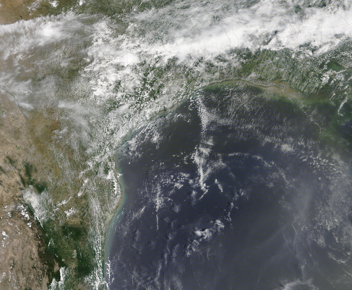
A “second wave” of Saharan dust swept over the Gulf of Mexico as an exceptionally dusty month over the Atlantic came to a close on June 30, 2020. The Moderate Resolution Imaging Spectroradiometer (MODIS) on board NASA’s Terra satellite acquired a true-color image of the sandy scene on that same day.
Dust storms are common across the Sahara Desert, especially in the spring, summer and early fall. It has been estimated that winds loft about 800 million of metric tons of dust from North Africa. By summer, large sheets of dust often stretch across the Atlantic Ocean, sometimes even reaching the Caribbean, Mexico, South America, and North America. But the intensity and extent of a plume of the Saharan dust that departed Africa on June 14 was anything but ordinary. One of the largest seen in decades, it has been called “historic” by several meteorologists, while the term “Godzilla” dust cloud found popularity on social media.
On June 24 the dust was passing over the Yucatan Peninsula, Mexico, sparking warnings that citizens should wear masks while the dust passed, especially those with respiratory problems. On June 25, the Washington Post reported that the nearly 5,000-long plume was moving ashore along the coast Gulf of Mexico from Texas to the Florida Panhandle. By June 29, most of the dust had moved off the Southeastern coast of the United States as another Saharan plume was sweeping across the Atlantic and approaching the Gulf of Mexico. This second plume, smaller and not as dense as the first, arrived to blanket the Gulf of Mexico and cover parts of northeastern Mexico and the southeastern coast of Texas on June 30.
While a single true-color image can give an excellent view of the conditions at a single point in time, comparisons of the same area between different days can give a better appreciation of an event across time. A roll-over comparison between this true-color image, acquired on June 30 by Terra, and a true-color image acquired by Terra on June 29 can be viewed
HERE. The earlier image shows clear skies, while the diffuse and broad plume of dust has covered the entire region by June 30. The scope of the images may changed by using the +/- icons on the far right of the comparison image. When expanded it is possible to view additional dust in transit from Africa over the Atlantic Ocean.
Image Facts
Satellite:
Terra
Date Acquired: 6/30/2020
Resolutions:
1km (433.3 KB), 500m (1.4 MB), 250m (2.9 MB)
Bands Used: 1,4,3
Image Credit:
MODIS Land Rapid Response Team, NASA GSFC
A “second wave” of Saharan dust swept over the Gulf of Mexico as an exceptionally dusty month over the Atlantic came to a close on June 30, 2020. The Moderate Resolution Imaging Spectroradiometer (MODIS) on board NASA’s Terra satellite acquired a true-color image of the sandy scene on that same day.
Dust storms are common across the Sahara Desert, especially in the spring, summer and early fall. It has been estimated that winds loft about 800 million of metric tons of dust from North Africa. By summer, large sheets of dust often stretch across the Atlantic Ocean, sometimes even reaching the Caribbean, Mexico, South America, and North America. But the intensity and extent of a plume of the Saharan dust that departed Africa on June 14 was anything but ordinary. One of the largest seen in decades, it has been called “historic” by several meteorologists, while the term “Godzilla” dust cloud found popularity on social media.
On June 24 the dust was passing over the Yucatan Peninsula, Mexico, sparking warnings that citizens should wear masks while the dust passed, especially those with respiratory problems. On June 25, the Washington Post reported that the nearly 5,000-long plume was moving ashore along the coast Gulf of Mexico from Texas to the Florida Panhandle. By June 29, most of the dust had moved off the Southeastern coast of the United States as another Saharan plume was sweeping across the Atlantic and approaching the Gulf of Mexico. This second plume, smaller and not as dense as the first, arrived to blanket the Gulf of Mexico and cover parts of northeastern Mexico and the southeastern coast of Texas on June 30.
While a single true-color image can give an excellent view of the conditions at a single point in time, comparisons of the same area between different days can give a better appreciation of an event across time. A roll-over comparison between this true-color image, acquired on June 30 by Terra, and a true-color image acquired by Terra on June 29 can be viewed HERE. The earlier image shows clear skies, while the diffuse and broad plume of dust has covered the entire region by June 30. The scope of the images may changed by using the +/- icons on the far right of the comparison image. When expanded it is possible to view additional dust in transit from Africa over the Atlantic Ocean.
Image Facts
Satellite:
Terra
Date Acquired: 6/30/2020
Resolutions:
1km (433.3 KB), 500m (1.4 MB), 250m (2.9 MB)
Bands Used: 1,4,3
Image Credit:
MODIS Land Rapid Response Team, NASA GSFC
