
Images


July 22, 2020 - Snow in the Andes
 Tweet
Tweet
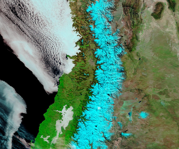
By mid-winter, 2020, a thick blanket of snow draped the Andes Mountains. This false-color image, acquired by the Moderate Resolution Imaging Spectroradiometer (MODIS) on board NASA’s Aqua satellite on July 15, dramatically highlights the broad bank of snow sitting atop the highland in Chile and Argentina.
In true-color images, which use visible light (bands 4,2,1) to create the image, snow, ice, and cloud all share similar reflectivity and appear white in color, making them difficult to tell apart. By using a combination of visible and infrared lights (bands 7,2,1) the differences become quite apparent. Here cold snow and ice both appear as electric blue and cloud still looks white. Vegetation is green and open soil appears brown or tan. The faint electric blue tint in parts of the cloud bank illustrates that the cloud tops are cold and contain ice crystals. A grayish-white swath lying atop green vegetation marks the thin cloud typical of low-lying fog which sits in a valley. The deep waters of the Pacific Ocean are tinted deep black in this false-color image while shallower inland lakes appear dark inky-blue.
The Andes are the longest series of mountain ranges the world, spanning about 4,500 miles (7,242 km) in length and running through seven countries. The political boundary between Chile and Argentina runs through the rugged mountain terrain, with Chile lying to the west and Argentina to the east.
Snowpack that accumulates in the mountains each winter is the primary source of water for communities at lower altitudes. Streams deliver the melt water to populated areas of Argentina and central Chile, where it is particularly important for cities’ water supply, power generation, and agriculture.
Image Facts
Satellite:
Aqua
Date Acquired: 7/15/2020
Resolutions:
1km (268.6 KB), 500m (657.6 KB), 250m (1.2 MB)
Bands Used: 7,2,1
Image Credit:
MODIS Land Rapid Response Team, NASA GSFC
